


|
||

|

|
|

|
Richard Edes Harrison's First Map
First state of the first map drawn by Richard Edes Harrison, one of the most influential mapmakers of the first half of the 20th Century.
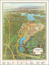
Drawn several years prior to his first job as a mapmaker with Fortune Magazine, this lithographed bird's eye view of New York City looking north from Washington Square, is the first map from Harrison. Most importantly, it foreshadows one of his trademark innovations, the use of a curved earth as a visual component of his work.
Richard Edes Harrison, renowned for his exceptional skills as a graphic artist and cartographer, emerged as a pivotal figure in the realm of data visualization, particularly through his innovative map designs during the Second World War. His unique approach to mapping, exemplified in an early work depicting New York City, marked a significant departure from conventional cartography. Created amidst the challenges of the Great Depression, this piece was part of Harrison's extensive contributions to design and advertising during this period.
Commissioned by the Herald Square Hotel, the map is distinguished by the hotel's prominent red depiction in the foreground. This vivid portrayal initiates a comprehensive panoramic view, seamlessly encompassing Manhattan Island, New Jersey, the Bronx, and Queens. The illustration is remarkable for its meticulous detailing of major landmarks and points of interest, skillfully combined with ornate yet clear typography.
There are several states of the map. This appears to be the earliest state, with no sign of Rockefeller Center (which appears on the state of the map dated 1932, no sign of the "Site of the World's Fair," and no reference the the Henry Hudson Bridge or Henry Hudson Parkway. The Queens Midtown Tunnel is also not shown (Lincoln Tunnel).
Rarity
The view is rare on the market. We note only one example of the first state of the map offered for sale by Swann Galleries in the past 10 years.
The later states are also scarce.
Richard Edes Harrison was a distinguished American scientific illustrator and cartographer, widely acknowledged for his innovative data visualization and cartographic methods. Harrison was notably the house cartographer for "Fortune" magazine and served as a consultant at "Life" for nearly two decades. His contributions were pivotal in reshaping cartographic perspectives and influencing spatial thinking.
The son of biologist Ross Granville Harrison, Richard grew up in New Haven and pursued his education at Yale College. He graduated with a major in zoology and a minor in chemistry. Initially, Harrison worked as a draftsman for architect Cass Gilbert and aspired to become an architect himself. This led him to the Yale School of Fine Arts in 1926, where he studied for four years. However, the economic downturn of the Great Depression impacted the field of architecture, prompting Harrison to shift his focus to design work.
Harrison's entry into cartography in 1935 was somewhat serendipitous, stemming from a friend's request to temporarily replace a mapmaker at "Fortune." During World War II, his cartographic visualizations gained significant popularity. He advocated for a multi-perspective approach to geographic issues and critiqued conventional practices, such as the overreliance on the Mercator projection and the standard placement of north at the top of maps.
His groundbreaking work included the azimuthal projection map titled "The World Divided," first published in "Fortune" in August 1941. This map, which was extensively replicated, underscored the United States' central role in global conflict. A later version, "One World, One War," appeared in "Fortune" in March 1942 and was ordered in large quantities by the U.S. Army. Harrison’s design influenced the creation of the United Nations logo and his maps were characterized by their unique tilted perspectives.
Despite considering himself more of an artist than a cartographer, Harrison had a highly successful career in mapmaking. He was part of the staff at "Fortune" from 1936 to 1938 and worked as a map consultant at the State Department and the Office of Strategic Services, the CIA's precursor, in the 1940s and 1950s. His expertise was also sought by the Museum of Modern Art. Harrison lectured at several universities, including Clark, Syracuse, Columbia, and Trinity, and was a member of both the American Geographical Society and the Royal Geographical Society.
His contributions extended to the realm of geopolitics, where he produced maps for Nicholas Spykman's "America's Strategy in World Politics," a seminal work in 20th-century geopolitics. Harrison's legacy in cartography and data visualization remains significant, as he fundamentally challenged and transformed the way maps were perceived and used in understanding world affairs.
![[Long Island City - Blackwell's Island Bridge]](https://storage.googleapis.com/raremaps/img/small/59904.jpg)
![[ New York City Wall Map ] Map Showing the High and Low Water Mark and the Original City Grants of Lands Under Water Made to Various Parties from 1686 to 1873, extending from Battery to Fifty-first Street, Hudson and East Rivers, New York City Also The Several Pier and Bulk-Head Lines Established from 1750 to 1873. Made Under the Direction of the Department of Docks 1873](https://storage.googleapis.com/raremaps/img/small/96356.jpg)
![[Lower East Side / Manhattan] Map of Delancy's Farm Eastern Part.](https://storage.googleapis.com/raremaps/img/small/59384.jpg)