|
||

|

|
|

|
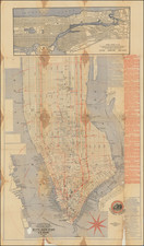
Rare map of New York City, likely pubished about 1890.
Shows Manhattan and the Bronx, with adjacent parts of Brooklyn, Long Island City, Jersey City and Hoboken. Includes index to hotels, prominent institutions and buildings, churches, places of amusements. Shows piers, ferry lines and railroads.
While the map would seem to come from a guide book from the period, this is unconfirmed. Haskell located two examples of the map with this title in guide books in the New York public library.
Rarity
We note two examples, New York Public Library and American Geographical Society (University of Wisconsin, Milwaukee). Both given tentative dating and were unable to identify the source.
The NYPL example is in two pieces, pasted on both sides of support paper.
No copies in OCLC.
![Manhattan Beach [New York]](https://storage.googleapis.com/raremaps/img/small/87616.jpg)
![Vereinigte Staaten von Nord-Amerika [Views of New York City and Back Country Scenes]](https://storage.googleapis.com/raremaps/img/small/25442.jpg)