|
||

|

|
|

|
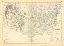
Wyoming Attached To Dakota Territory
Fascinating map of the United States, produced by the Society for the Diffusion of Useful Knowledge, offeringa captivating cartographic snapshot of a nation in the throes of significant geographical and political change. Created during the turbulent times of the Civil War, this map illustrates the fluid nature of the U.S. western territories, with a particular emphasis on the evolving boundaries of the Wyoming Territory.
Founded in 1826, the Society for the Diffusion of Useful Knowledge had the mission of providing educational material to the expanding literate populace. This map, beyond its functional role, is emblematic of the Society's dedication to knowledge dissemination during a transformative era in U.S. history.
In the period leading up to 1864, the western territorial boundaries underwent consistent alterations. The depiction of regions like Dacotah and the evolving depiction of the boundaries of Idaho Territory prior to the creatioin of Montana Territory in 1864 highlight the provisional and evolving nature of these borders. States and territories during this period weren't just geographical units; they were political constructs that emerged from exploration, settlement, and economic imperatives.
Wyoming Territory, which would be officially recognized in 1868, is here shown as part of the vast Dacotah Territory. The carving out of Wyoming was influenced by the requirements of an increasing population, political strategies, and the significant infrastructural endeavors like the transcontinental railroad.
The evolution of the Dakota Territory is particularly notable. Established in 1861 when it was severed from Minnesota Territory, it experienced numerous border changes until it was finally divided into North and South Dakota in 1889. Originally spanning portions of what is now Wyoming and Montana, its boundaries were reshaped by land claims, explorations, and an aspiration for administrative efficiency. As territories like Wyoming emerged, the confines of Dakota were continuously redefined.
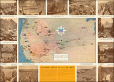
Exploration played a crucial role in the territorial configurations of this period. The U.S. Pacific Railroad Surveys (USPRR) in the 1850s and 1860s significantly advanced the understanding of the region's landscape and the potential avenues for railway connections. The efforts to identify viable routes to link the coasts inadvertently propelled the drive for territorial organization.
Simultaneously, the early explorations of the Yellowstone region, particularly in the late 1860s, were monumental. Expeditions, such as those spearheaded by F.V. Hayden, deepened the comprehension of Yellowstone's unique geothermal features and ecological wonders. While the primary goal was scientific discovery, these explorations also influenced territorial demarcation and the push for statehood.