


|
||

|

|
|

|
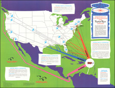
Union Pacific Railroad Promotional Map, 1940: A Glimpse into the Western Wonders
This map from 1940 serves as a captivating promotional piece for the Union Pacific Railroad, intending to both inform and allure potential travelers to the myriad wonders of the American West. Richly detailed, it intertwines a map of the lines of the Union Pacific to the West with evocative imagery, revealing the vast expanse of the Western United States and its breathtaking landscapes accessible by rail.
The central focus is a map that traces the extensive network of the Union Pacific Railroad. The geographic span stretches from the Midwestern states, such as Minnesota and Illinois, to the Pacific coastlines of California and Oregon.
Surrounding map, a selection of sepia-toned photographs showcases iconic tourist attractions and natural marvels of the West. These include stunning vistas such as the majestic Grand Canyon, the serene Mirror Lake in Yosemite Valley, and the rugged landscapes of the Rocky Mountains. Alongside these natural wonders, glimpses into the vibrant urban life of the era are presented, such as the sprawling cityscape of Salt Lake City, which stands in contrast to the wild beauty of its surrounding environs.
Below the map, the bold proclamation, "GO UNION PACIFIC TO ALL THE WEST," firmly positions the railroad as the premier choice for travelers keen on experiencing the West's splendors. Although direct appeals for purchase are absent, the implicit message is clear: an unforgettable journey awaits those who choose to traverse the landscape on the tracks of the Union Pacific.
In essence, this promotional map from 1940 is more than a mere navigational tool; it is a window into a bygone era of exploration and discovery. It encapsulates the allure of the American West and the significant role the Union Pacific Railroad played in bridging the vast distances, making the region's beauty and wonder accessible to all.

![[ Mount Vernon ] The Kitchen Garden of Mount Vernon, Seat of General George Washington in Viginia, The Design of an Elegant Kitchen and Fruit Garden Containing 0.92 Acres](https://storage.googleapis.com/raremaps/img/small/101604.jpg)
![[ US-Mexico Border Survey: General Order From the President of the United States Directing William H. Emory to lead the US-Mexico Boundary Survey ]](https://storage.googleapis.com/raremaps/img/small/101837.jpg)
![[Imperial Valley]](https://storage.googleapis.com/raremaps/img/small/69292.jpg)