|
||

|

|
|

|
What Happens When the Dams Break.
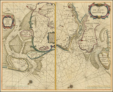
A beautifully detailed map of the Groningen province, based on the work of Barthold Wicheringe. This map prominently features the Dollert estuary and includes a historical note about the devastating flood of 1277 (actually 1287) that led to the formation of the estuary and the destruction of several villages. It includes an inscription: "Anno 1277 Maris inundatione triginta tres pagi hoc in loco periere," which translates to "In the year 1277, thirty-three villages perished here due to a sea flood."
The map is rich in details such as roads, dikes, fortified cities, and illustrated topographical features. The map is further enhanced by two ornate cartouches: one for the title, adorned with a classical warrior and a symbol of justice, and another for the scale of miles, decorated with figures engaged in farming activities.
St. Lucia's Day Flood
Saint Lucia's flood, occurring on December 14, 1287, was one of the most catastrophic floods in recorded history, impacting the Netherlands and Northern Germany. This devastating event resulted from a combination of a severe storm and high tides, leading to the breaching of dikes and subsequently causing widespread destruction. The flood was particularly significant as it reshaped the coastline of the affected regions, altering the geography and leading to the formation of the Zuiderzee, a large inland sea in the northwestern Netherlands. The flood resulted in immense loss of life, with estimates suggesting that thousands of people perished. It also had long-term socio-economic consequences, as it destroyed vast tracts of fertile land and numerous settlements, fundamentally changing the landscape and the way of life in the region for centuries to come.
Willem Janszoon Blaeu (1571-1638) was a prominent Dutch geographer and publisher. Born the son of a herring merchant, Blaeu chose not fish but mathematics and astronomy for his focus. He studied with the famous Danish astronomer Tycho Brahe, with whom he honed his instrument and globe making skills. Blaeu set up shop in Amsterdam, where he sold instruments and globes, published maps, and edited the works of intellectuals like Descartes and Hugo Grotius. In 1635, he released his atlas, Theatrum Orbis Terrarum, sive, Atlas novus.
Willem died in 1638. He had two sons, Cornelis (1610-1648) and Joan (1596-1673). Joan trained as a lawyer, but joined his father’s business rather than practice. After his father’s death, the brothers took over their father’s shop and Joan took on his work as hydrographer to the Dutch East India Company. Later in life, Joan would modify and greatly expand his father’s Atlas novus, eventually releasing his masterpiece, the Atlas maior, between 1662 and 1672.
![[Low Countries ] Belgium Foederatum emendate auctum et novissime editum](https://storage.googleapis.com/raremaps/img/small/98432.jpg)