


|
||

|

|
|

|
Stock# 88398
Description
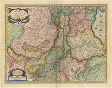
Fine original antique map of the formerly coastal province of Gelderland, before the draining of Flevoland.
The map shows the province in fine detail, with its cities, roads, forests, marshes, and small hills (labeled sandbars) all shown. Major cities in the area, mostly on the outside of the province, are highlighted in red. This include Campen, Arnheim, Nimmegen, and Doesburg. The map includes three decorative cartouches and a compass rose.
This map was published by Peter Schenk and Gerard Valk in Amsterdam at the end of the 17th century.
Condition Description
Original hand-color, in outline. Minor toning and fold toning.
![[Amsterdam] Amstelredamum, Nobile Inferioris Germaniae Oppidum](https://storage.googleapis.com/raremaps/img/small/96920.jpg)
![[Monastery Ter Apel] Petite carte des environs de Klooster ter apel et de Rooswinkel . . . 1796](https://storage.googleapis.com/raremaps/img/small/60565.jpg)
![[Denmark, Netherlands, Belgium, North Sea] Europ IIII Tab](https://storage.googleapis.com/raremaps/img/small/89170.jpg)