|
||

|

|
|

|
Stock# 79400
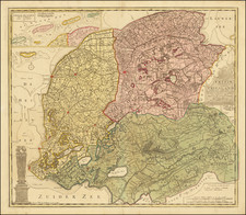
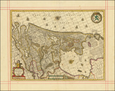
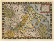
Description
Scarce and highly detailed map of the Low Countries, published by Valk, father and son. Finely colored and expertly engraved, the map includes a high level of detail, locating towns, roads, rivers, lakes, islands, and other features of interest.
The map highlights cities of importance in red and shows forests and marshes pictorially. Detail extends from the Dollard Sea on the Dutch-German border to Bruges, in Belgium.
Condition Description
Original hand-color in outline. Manuscript pencil underlining of important towns. Minor soiling in the North Sea.
![Belgii Pars Septentrionalis communi nomine Vulgo Hollandia…[Inset Views of New Amsterdam (New York City) & Batavia and Maps of NE United States and SE Asia]](https://storage.googleapis.com/raremaps/img/small/78398.jpg)