|
||

|

|
|

|
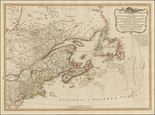
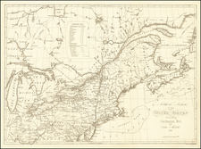
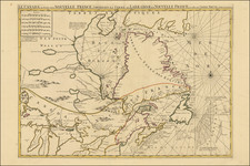
The Webster-Ashburton Treaty Map
Finely detailed mapping of the area around Maine, Northern Vermont and New York, and the contiguous parts Quebec and New Brunswick illustrating the contentious boundary dispute between the United States and the British territories as they stood in the early 19th century.
The map is a comprehensive cartographic depiction of the claims and final outome resolving the ambiguities left by the Treaty of Paris of 1783, which had concluded the American Revolutionary War. This treaty ambiguously demarcated the borders between the newly independent United States and British North America, particularly around Maine and the area south of the St. Lawrence River and east of Montreal, leading to several disputes.
The dispute was grounded in the precise nature of the northeastern border between the United States and the British territories in North America, specifically the area that is now the border between the U.S. state of Maine and the Canadian province of New Brunswick. After the Treaty of Paris in 1783, the border was supposed to follow the "highlands" that divided waters flowing into the St. Lawrence River from those flowing into the Atlantic Ocean, starting from the northwesternmost head of the Connecticut River and then proceeding along these highlands to the headwaters of the St. Croix River. However, the "highlands" described in the treaty were not the same as the ones known to the negotiators. The source of the Connecticut River was also subject to various interpretations, further complicating the matter. For the British, maintaining control over the Saint John River watershed was of prime strategic importance, as it provided a direct route to the city of Quebec, a key military and trade node. The Americans, on the other hand, interpreted the border to include a significant portion of the watershed within Maine.
The resulting ambiguity led to competing claims. The U.S. claimed (as shown by the blue line) the land up to the natural watershed of the St. John River—basing their claims on the description provided in the Treaty of 1783—while Britain claimed the red line further to the south, which would include the route to Quebec and parts of the northern Maine territory. The map illustrates the "Aroostook Valley" and disputed territory, areas where the claims overlapped and which became the flashpoint for the Aroostook War, an undeclared conflict that consisted mainly of saber-rattling and militia movements.
The map specifies the River St. Croix, which was accepted as the starting point of the boundary, but from there, the exact path to be taken was mired in uncertainty. The British claimed that the border should be drawn more southerly, passing through Mars Hill and effectively cutting off a large swath of what is now northern Maine from the United States. Conversely, the U.S. argued for a more northerly boundary that would follow the crest of the highlands and leave the entire Aroostook River basin within Maine. The resolution of the conflict came through the Treaty of Washington or Webster-Ashburton Treaty, following an international arbitration conducted by the King of the Netherlands to settle some disputes and direct negotiation for others. The treaty not only clarified the geographic boundaries but also included terms for shared use of the Great Lakes and established a definitive border from Lake of the Woods to the Rocky Mountains.
The detailed work of surveyors like Graham and Renwick was crucial in delineating these claims on the map, and their annotations provide invaluable insights into the geographical context of the dispute. Their surveys were instrumental in the eventual negotiation of the Webster-Ashburton Treaty of 1842, which finally resolved the dispute (as illustrated in pink) and the subsequent Boundary established by the Treaty of 1842 (in green), a compromise which gave a bit more land to Britain, most notably the road demarcated on the map as British Military and Mail Road To Quebec, wich connected Quebec to the Atlantic Ocean via the St. John River.
The Treaty of Washington, or the Webster-Ashburton Treaty, essentially split the difference between the claims, with the final border running down the middle of the disputed territory. The map reflects the outcome of the treaty and the various claims, with the boundary running along the St. John River, then westward along the 45th parallel north until it meets the St. Lawrence River, and finally including a delineation around Rouse's Point. The treaty was a significant achievement in international diplomacy and set the stage for more peaceful U.S.-Canadian relations in the years to follow.
Titled “Map of the Boundary Lines between the United States and the Adjacent British Provinces,” the map was meticulously under the directions of the United States Senate and compiled from surveys conducted under the authority of the United States, directed by notable figures such as Major J.D. Graham and Lieutenant T.J. Lee. According to the detailed notes inscribed on the map, the delineation of the boundary lines was drawn from various authoritative sources, including the United States Bureau of Topographical Engineers and surveys by James Renwick, Lieutenant T.J. Lee, and others. The boundary from the source of the River St. Croix to the head of the Connecticut River was derived from these surveys and maps created by David H. Burr, depicting the territories claimed by Great Britain and the adjustments made following the Webster-Ashburton Treaty.
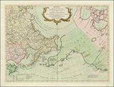
The inset titled "Rouse's Point and its Vicinity on Lake Champlain" provides a zoomed-in view of a strategically important area. This inset shows the fortifications at Rouse's Point, which was particularly notable for its proximity to the 45th parallel, a line that had been previously thought to be the border before the Webster-Ashburton Treaty. The corrections made by the treaty were critical as Rouse’s Point was initially thought to be in Canada but was affirmed as U.S. territory through the negotiations.
The outcome of this diplomatic effort had a lasting impact on the local populations and the development of the region. It allowed for peaceful settlement and development of the areas along the border and prevented any further military escalation between the two nations. It also set a precedent for peaceful resolution of international disputes through negotiation and arbitration.
This historical map, therefore, is not merely a cartographic representation of a geopolitical boundary but a narrative of a complex episode of American and British history. It symbolizes the end of a boundary dispute that had simmered for decades and the establishment of a border that has endured. It is a document that speaks to the intricate dance of diplomacy, the power of surveying and mapping, and the importance of clear boundaries for the peace and stability of nations.
The present map was prepared for by Congress to lay out the final results of the Treaty. The map was engraved by W.J. Stone and notes at the bottom right that it was "Printed by order of the Senate of the U.S. of March 3d. 1843." The map was compiled by Lieut. T.J. Lee of the Corps of Topographical Engineers and W.M.C. Fairfax, civil engr.; under the direction of Major J.D. Graham, Corps of Topographical Engrs., one of the commissioners for surveying and exploring the north eastern boundary of the U.S. as directed by the Dept. of State.
States of the Map
There appear to be two states of the map:
- Thick Paper (most of which include handwritten inscriptions by James D. Graham, one of the mapmakers and a Commissioner of the Boundary Commission)
- Thin Paper: Bound into the Congressional Report of the Webster Ashburton Treaty
In recent years, Sothebys offered for sale a daguerreotype portrait of James D. Graham posing with the map.
Rarity
The map is of the utmost rarity, with almost all known examples bearing gift inscriptions by J.D. Graham, one of the principal mapmakers, to various national and other important libraries.
We locate the following examples offered for sale:
- 1940: Goodspeeds Catalog 328, item 147 ( with a presentation inscription by JD Graham)
- 1932: Stan V. Henckels Catalog 1470, Item 84 (in the archive of Colonel William G. Williams (1801-1846), Superintendent of the Survey of the US Boundary for the Northwestern Great Lakes)
- 1910: Merwin-Clayton Catalog 341, Item 234
We locate copies in the Library of Congress, New York Public Library, Harvard University (presented to Harvard in 1844, by JD Graham, one of the mapmakers), University of Michigan (presented to the Ducal Palace of Modena by JD Graham, one of the mapmakers in 1844 and second example presented by JD Graham to the Library of the University of Geneva in 1847), Canadian National Archives (presented by JD Graham to the Library of the University of Basle in Switzerland in 1847), Massachusetts Historical Society, British Library and American Philosophical Society (per Catalog of 1863).
Provenance: Mess Room, Royal Artillery of Engineers, Quebec (hand written note at bottom).
![Partie De L'Amerique Septent? Qui comprend La Nouvelle France ou Le Canada . . . [Large Great Lakes Inset]](https://storage.googleapis.com/raremaps/img/small/48752.jpg)