|
||

|

|
|

|
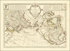
A rare and significant map of the Northwest Coast of America and Northeast Coast of Asia by Carington Bowles and Samuel Carver, circa 1780, illustrating the Russian discoveries of Captains Bering and Tschirikow.
This Bowles and Carver edition is based on Thomas Jefferys' groundbreaking map that provided important details about the early Russian exploration of the Northwest Coast of America. At the time, the map offered crucial insights into the region, with its depictions of the routes taken by Bering, Tschirkow, and three anonymous Russian voyages. The map also highlights the efforts to find the elusive Northeast Passage and the overland expeditions of Cossack Schestakow and Captain Panlutzki in Siberia.
The annotations within the map record the dates of various landings along the coast of Alaska and Western Canadian Coastline, revealing a detailed picture of exploration during this period. Notably, the cartography is more conservative than other contemporary maps, avoiding the inclusion of speculative information. De Font and De Fuca are mentioned, as well as the River of the West, which was believed to traverse the interior and connect to Hudson's Bay.
In conclusion, this rare Bowles & Carver edition of Thomas Jefferys' seminal map stands as a valuable artifact, capturing the state of knowledge about the Northwest Coast of America and Northeast Coast of Asia in the late 18th century. The map's annotations and relatively restrained cartography provide an insightful glimpse into the early Russian exploration of this region, making it a significant addition for those interested in the history of cartography and the exploration of the Americas.
![Asie . . . 1650 [with unusual depiction of the West Coast of North America and the Island of Corey]](https://storage.googleapis.com/raremaps/img/small/102556.jpg)