|
||

|

|
|

|
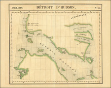
Rare map of the Northeastern United States, which first appeared in John Melish's Traveller's Directory… published in Philadelphia.
This Northern Sheet, previously titled Map of the Seat of War…extends from the Great Lakes to Nova Scotia, New Jersey, Maryland and Ohio, showing portions of the nascent Indiana Territory and all of Michigan Territory. The map illustrates the various states and provinces, with roads, towns, distances, Forts and other early information contemporary to the War of 1812.
The present example was re-engraved and issued in Axel Klinkowstrom's Bref om de Förenta Staterna. Klinkowstrom was a Swedish Baron active in the late 18th and early 19th century. Pressured by his ambitious father, Klinkowström joined the Swedish navy as an ensign at 17 and rose, in the course of a long career, to the rank of Lieutenant-Colonel. Between 1818 and 1820 Klinkowström traveled to the United States to investigate the American invention of the steamboat and assess its military potential for the Swedish navy. During his American tour Klinkowström composted some 25 illustrated letters which were published in 1824, roughly four years after his return to Sweden.
John Melish (1771-1822) was the most prominent American mapmaker of his generation, even though his cartographic career lasted only a decade. Melish was born in Scotland; he moved to the West Indies in 1798 and then to the United States in 1806. By 1811, he had settled in Philadelphia and published Travels through the United States of America, in the years 1806 & 1807, and 1809, 1810, & 1811, which was richly illustrated with maps.
Melish created several regional maps of the highest quality, as well as the Military & Topographical Atlas of the United States (Philadelphia, 1813, expanded 1815). The latter work is widely considered to be the finest cartographic publication to come out of the War of 1812.
By far his best-known work is his monumental map of the United States of 1816, Map of the United States with the contiguous British and Spanish Possessions. He began working on the map in 1815 and sent it to Thomas Jefferson for comment in 1816. Jefferson enthusiastically reviewed the map and returned it with his edits. Jefferson later hung an example of the map in the Entrance Hall of Monticello and sent it to associates in Europe.
Melish’s finished product was the first map of the United States to extend to the Pacific Ocean. After its publication in 1816, Melish ensured the map was as up-to-date as possible; it was reissued in 25 known states published between 1816 and 1823. The map captured the then rapidly changing geography of the United States, as well as various boundary disputes, treaties, and expansion.

![[ Native Mexican Warrior ] Ein Mexicaner](https://storage.googleapis.com/raremaps/img/small/94089.jpg)

![[ New York State Western Frontier ] A Plan of Township No. Ten in the First Range - Each Lot Containing 192 Acres. Except the first Range of Lots on the South Side the Contents of which is Set against each Lot South. [Manuscript cadastral map of a portion of the Phelps and Gorham Purchase in Ontario County, New York].](https://storage.googleapis.com/raremaps/img/small/81444.jpg)