|
||

|

|
|

|
The First Large Scale Map of London After The Great Fire of 1666
1904 edition of this rare wall map of London, with a large birdseye view of London, based upon the surveys of William Morgan, prepared for the London Topographical Survey.
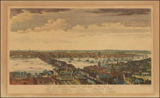
This remarkable survey of the City of London and the surrounding built-up area (including Westminster and part of Southwark) was prepared on a scale of 300 feet to the inch and completed in 1682 by William Morgan. At the bottom is "A prospect of London and Westminster taken at several stations to the southward thereof, by Robt. Morden & Phil. Lea," with extensive indexes, diagrams of government and university administrators' names, dedication statements, text, tables, and profile views of buildings.
Morgan's map was the first map of London produced on a uniform scale based upon an actual survey. Interestingly, Morgan eliminates a number of the less attractive elements of city, such as the jails, slums, workhouses and evidence of poverty and unsanitary conditions which existed on the east side of London, and also offers an idyllic look on the west end, with deer grazing in St. James Park.
The 1682 Map of London by William Morgan represents a significant cartographic production, offering a detailed survey of the city’s layout post the Great Fire of London. This map alone was printed using sixteen copperplates and measured 8 feet by 5 feet. Morgan’s undertaking, which spanned sixteen years, is the first large scale map of the city after the Great Fire. The map showcases the newly ordered London, perhaps more systematic than the city's true nature at the time, aligning with the ideals of urban design of the era.
Accompanying Morgan’s map is the prospect by Robert Morden and Philip Lee, which offers a detailed view of the Thames River, rendered in a manner that straightens its natural meanderings for the sake of clarity and detail. This artistic decision marks a first in London’s cartographic history, illustrating every edifice and wharf along the river's course. The inclusive nature of this depiction ensures that every structure, regardless of its prominence, is represented.
This prospect, intended for attachment to Morgan’s larger work, was printed on four sheets and could be displayed either above or below the main map, offering a degree of customization to the owner.
For a marvelous overview of the original example in the British Library, this video featuring Peter Barber and other scholars is worth viewing.
"The London Topographical Society was founded in 1880 for the publication of material illustrating the history and topography of the City and County of London from the earliest times to the present day." (from the Society prospectus in 1900).
Rarity
The original map is exceptionally rare.
This 1904 facsimile is the first recreation of the map and is also rare on the market. We note only 2 examples at auction listed in RBH, including this example (purchased in 2023) and an example offered in 2005. No examples have been listed in AMPR.
Robert Morden (d. 1703) was a British map and globe maker. Little is known about his early life, although he was most likely apprenticed to Joseph Moxon. By 1671, Morden was working from the sign of the Atlas on Cornhill, the same address out of which Moxon had previously worked. Most famous for his English county maps, his geography texts, and his wall maps, Morden entered into many partnerships during his career, usually to finance larger publishing projects.
Philip Lea (fl. 1683-1700) was a central figure in the London map community at the end of the eighteenth century. He apprenticed under Robert Morden, with whom he later collaborated. Lea was made free of the Weavers Company in 1689. He was a publisher and a globe and instrument seller with ties to members of government. For example, Samuel Pepys lists him as his map advisor and colorist. He was not known primarily for his own original works, but for his reworking and reissuing of the work of others, particularly the county maps and world map of Christopher Saxton. He also acquired plates from John Seller, John Ogilby, and William Morgan, among others. Later in his career, he collaborated frequently with Herman Moll. After his death in 1700, Philip’s wife, Anne, carried on the business for several decades.

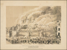
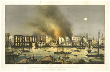
![The Tower of London, As Seen October 31st 1841 [the morning after the fire]](https://storage.googleapis.com/raremaps/img/small/92003.jpg)