|
||

|

|
|

|
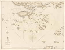
The Viceroy's Plan for Dividing Western North America Between Spain and Great Britain.
As the 18th century drew to a close, the Pacific Northwest emerged as a hotbed of international intrigue and diplomacy, with Russia, the United States, Spain, and Britain vying for control on one of the last frontiers of European exploration. This period of tumult and uncertainty gave rise to this remarkable map, which encapsulates Spain's territorial ambitions and exploratory achievements in this period. This hand-drawn map, produced in 1792 under the direction of Viceroy Juan Vicente de Güemes Padilla Horcasitas y Aguayo, 2nd Count of Revillagigedo, is deeply intertwined with the broader narrative of European colonial expansion and competition in the present-day Pacific Northwest of the United States and Canada.
The story of this map begins with the Nootka Crisis, a contentious episode that unfolded between 1789 and 1790, catalyzed by conflicting Spanish and British claims over the Pacific Northwest. This region, rich in resources (namely fur, at the time) and strategic opportunities, had drawn the attention of both empires, leading to a series of expeditions and encounters that heightened tensions. The crisis was rooted in the encounter at Nootka Sound, where the Spanish, under the command of Esteban José Martínez, seized British vessels, under the command of James Colnett, engaged in the fur trade. This act ignited a dispute that threatened to escalate into a full-blown war.
The resolution of this crisis came with the Nootka Convention of 1790, an agreement that aimed to defuse tensions by delineating spheres of influence and settlement rights in the Pacific Northwest. Eventually, three separate Nootka Conventions were signed, and it took over five years to resolve the many outstanding problems.
Viceroy Revillagigedo appointed Captain Bodega y Quadra to negotiate with George Vancouver, the British envoy, to put the terms of the Nootka Convention into effect. Central to this plan was the establishment of a permanent boundary through the middle of the Strait of Juan de Fuca, a proposal that aimed to provide a lasting solution to the territorial ambiguities plaguing Spanish-British relations in the region.
The Map
According to Henry Wagner (Cartography of the Northwest Coast, Vol. I, page 231; Vol. 2, page 359), the Viceroy Revillagigedo commissioned this map (Wagner #814) to support his diplomatic initiative. The map includes statements of Spanish territorial claims from Monterey north to Prince William Sound, Alaska. These claims derived generally from Vasco Núñez de Balboa's sighting of the Pacific in 1513 and Martin de Aguilar's exploration of the Pacific Coast of North America in 1603, and specifically from the 1770s Spanish exploratory voyages including Juan Pérez in 1774, Bruno de Heceta (Hezeta) in 1775, Juan Francisco de la Bodega y Quadra with Francisco Antonio Maurelle in 1775, and Ignacio de Arteaga with Bodega y Quadra again in 1779.
The important claims from these voyages are noted on the map, from south to north:
Pto. de la Trinidad Posesn. por los Españoles en 1775. [Hezeta Expedition of 1775. Trinidad Harbor, California]
Ena. donde [dere?] estar el Rio de Martin de Aguilar [Martín de Aguilar Expedition of 1603. Unidentified river on the Oregon coast]
Ba. vista por Dn. Bruno Hezeta en 1775. [Hezeta Expedition of 1775. Columbia River, Washington and Oregon]
Ensa. de los Martires Posesion por los Españoles en 1775. [Hezeta Expedition of 1775. Grays Harbor, Washington]
Entrada en que estuvo D. Juan Perez el año de 1774. [Pérez Expedition of 1774. Hecate Strait, Alaska and British Columbia]
Ensa. de Bucareli Posesn. por los Españoles en 1774. [Pérez Expedition of 1774. Bucareli Bay, Prince of Wales Island, Alaska]
Ensa. de los Remedios Posesn. por los Españoles en 1775.
Pto. de S. Tiago Posesion por los Españoles en 1779. [Arteaga and Bodega y Quadra Expedition of 1779. Gulf of Alaska.]
Despite the map's assertion of Spanish possession extending to Alaska, the Viceroy intended to relinquish Spain's claims above the Strait of Juan de Fuca (here, "Entrada de Fuca"), including the contested Nootka Sound, with the Spanish to be relocated south to Neah Bay, Washington. To this end, the map features a boundary line stretching from the southwest point of Vancouver Island (not then recognized to be an island) directly north to the sixtieth parallel, then eastward, accompanied by the legend "Esta linea puede ser la Demarcacion divisoria para precaver las internaciones" [This line can be the dividing demarcation to prevent incursions].
Perhaps the Viceroy believed that this configuration would mollify the British while leaving Spain with what were then still seen as the likeliest entrances to the long-sought-after Northwest Passage (namely "Entrada de Fuca").
The fate of Revillagigedo's proposal remains shrouded in mystery. Wagner states that the historical record is silent on whether this map and the boundary it depicted were ever formally presented to Vancouver or if they influenced the course of Anglo-Spanish negotiations.
This map summarizes Spain's self-conscious efforts to exert control on the Northwest Coast of America while simultaneously acknowledging its disinclination and lack of capacity to physically defend those claims against other powers (namely Britain).
Rarity
We record four separate examples of this manuscript, probably all done within a short window.
An example of the map at the Museo Naval in Madrid, reproduced in Wagner, Spanish Explorations in the Strait of Juan de Fuca, 61. Another example is located in the institution and is illustrated online here.
According to the 1971 Special List No. 26, Pre-Federal Maps in the National Archives: an Annotated List, there is an example in the National Archives. Note that this example is erroneously dated 1779 by the cataloger, presumably because this is the last date recorded on the map.
Wagner Quotes
Wagner, Cartography of the Northwest Coast of America, Volume I, page 231:
The envoy of Great Britain [i.e., George Vancouver] and Captain Bodega, whom the Viceroy now appointed to represent the King of Spain, were to meet in Nootka in 1792, to put the terms of the Convention into effect. The Viceroy wished to propose a permanent boundary between the possessions of the two powers through the middle of the Strait of Juan de Fuca and as a preliminary he wished Mourelle to ascertain which place on the south coast of the strait was best adapted for a permanent Spanish establishment. To display this plan a map was drawn (814) with a boundary line as suggested by the Viceroy. Whether Bodega ever presented this plan to Vancouver cannot be determined from any of the correspondence so far examined of either of these men.
Volume II, page 359, 814:
A peculiarity of this map is a boundary line drawn from about the southwest point of Vancouver Island directly north to the sixtieth parallel and then east with the following legend: "Esta linea puede ser la Demarcacion divisoria para precaver las internaciones." It seems to have been drawn up to illustrate the proposal of the Viceroy, Conde de Revilla Gigedo, in 1792 to divide the northern territory between Spain and Great Britain. The discoveries of the Spaniards are shown on the map and the places where possession had been taken. Some changes have been made: C. Toledo has been moved to 43° 12' and C. Diligencias to 42° 42'.
Provenance
Sotheby Atlases, Maps and Printed Books, 21 May 1984, lot 346, £4,620;
Robinson;
W. Graham Arader III, Catalog 49, Summer 1984, Item 8 ("A previously unrecorded example of a manuscript map resulting from the expedition of Bodega y Quadra."), $27,500;
Private American collection


![[ Lower Fraser Valley ] 200 Miracle Miles Through The Lower Fraser Valley](https://storage.googleapis.com/raremaps/img/small/101662.jpg)