


|
||

|

|
|

|
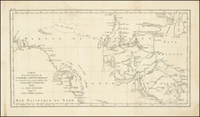
The "Preliminary Photo Compilation - Northern Alaska," compiled in October 1944 by the U.S. Geological Survey for the Army Air Force, is a compelling large-scale map predominantly emphasizing the hydrographical details of the region. With an approximate scale of 1:1,000,000 (1 inch equates to 16 miles), it provides an extensive aerial overview of the area. Sparse references to human habitation, such as "Native Village," "Cabin," and "Airfield," hint at the map's predominantly strategic and military objectives.
The map’s production in the final stages of World War II, marked by a period of intense geopolitical tension and military operations, gives it substantial historical importance. In 1944, the globe was entangled in a global conflict that significantly shifted the boundaries of power, and Alaska, owing to its geographical proximity to the Soviet Union, was of strategic importance to the U.S. military. Thus, this comprehensive topographical survey likely played a critical role in the planning and execution of military operations, logistics, and troop movements.
It is pertinent to note that during this time, the U.S. Geological Survey was actively involved in assisting the U.S. military by producing detailed and precise maps of strategic areas. Furthermore, the process of 'Trimetrogon Photography,' employed for the creation of this map, was a military aerial photography technique designed to produce large-scale maps with minimal distortion. This technique was commonly used during World War II for cartographic and reconnaissance purposes.
Apart from its geopolitical importance, the map also provides a detailed hydrographical study of the region, presenting intricate details of the Northern Alaskan landscape. It documents the region's extensive waterways, coastlines, and other bodies of water, contributing valuable historical data to the geographical and environmental knowledge of the area. In essence, the "Preliminary Photo Compilation - Northern Alaska," while fundamentally a strategic tool of World War II, offers valuable insights into the topography and hydrography of the region, thereby making it an important artifact of military and geographic history.

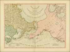
![(Mount St. Elias and Mt Fairweather to Cape Decision, Stika, Juneau and Prince Frederick Sound) Cote Nord-Ouest De L'Amerique Reconnue Par Cape. Vancouver Ve. Partie [Northwest Coast of America as recognized by Captain Vancouver, 5th Part]](https://storage.googleapis.com/raremaps/img/small/88128.jpg)
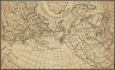
![Asie . . . 1650 [with unusual depiction of the West Coast of North America and the Island of Corey]](https://storage.googleapis.com/raremaps/img/small/102556.jpg)