|
||

|

|
|

|
Rare, Early Scientific Journal Map
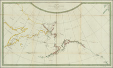
Fine, reduced-size example of Joseph-Nicolas De L’Isle and Philippe Buache’s influential 1752 map of the North Pacific from an unknown source, reporting the publication of the De L'Isle-Buache map and referencing Russian and Spanish voyaging in the Pacific Northwest and North Pacific.
In his fine work on the Sea of the West, Donald McGuirk labeled the map "unknown" and "rare."
De L'Isle and Buache first presented the map to the Acàdemie Royale on April 8, 1750; it was printed in June of 1752 and then quickly reissued across Europe. The map proved quite controversial after it was printed due to its inclusion of the Sea of the West, its publicizing of sources that the Russian Academy of Sciences considered their own, and flawed dependence on the apocryphal letters of Admiral de la Fonte--these are the Russian and Spanish sources mentioned in the title.
However, it also proved a tantalizing depiction, as very little was known about the North Pacific, and the possibility of a Northwest Passage in the area, in Europe at this time. This map, reproduced in a reduced size, was included in a multi-volume work and shows the dissemination of Buache and De L’Isle’s ideas.
The map shows North America and Russia arrayed near the North Pole on a seldom-used stereographic projection. Rather than show meridians and parallels meeting in right angles, the chart includes the curve of the earth, with latitude lines radiating in an arc, making it possible to show more area.
A large sea is in the interior of North America. A series of lakes nearly connects Baffin's Bay to the Mer du Sud, suggesting a Northwest Passage. To the north are glacial mountains while to the west are a series of archipelagoes and several large lakes. Further west, Russia appears well delineated, with the exception of an unfinished island supposedly discovered by the Russians in 1723.
Russian Discoveries
Joseph Nicholas De L'Isle spent much of his career in Russia, where he helped to found the Russian Academy of Sciences. While there, he had access to the latest findings of Russian explorers and was at the center of Russia's geographic establishment; for example, he helped produce the first Russian atlas, the Atlas Russicus, with Ivan Kyrilov. He returned to Paris in 1747 with a large map collection, an event that drew some criticism from Russian academicians who thought he absconded with delicate materials.
The map identifies Russian discoveries from the previous three decades. Two expeditions led by Vitus Behring (1728-30, 1733-43) explored Kamchatka and what is now Alaska, charting the strait between them. De L'Isle interviewed Bering and used his charts from the voyages. Their discoveries are marked with Bering's track in 1731, near Kamchatka, and the new geographic features in the Alaska area.
The map also includes the track of "Tschirikovÿ" in June and July of 1741. De L'Isle's half-brother, Louis De L'Isle de la Croyere, sailed with Captain Alexsei Chirikov (Tchirikov) to discover the fictional De Gama's Land, or Companies Land. Joseph Nicholas was convinced that the island existed and provided his half-brother with maps to support the hypothesis. de la Croyere perished on the voyage, but his brother received his papers and published his findings on the map.
Beyond the Russian discoveries, the map also shows the track of the 1743 Spanish galleon from Manila to Acapulco, as well as de Frondat's voyage of 1709. A Frenchman, de Frondat followed the usual galleon route and attempted to trade with Spanish settlers once he reached Baja California. He later sold his goods in Peru and Chile and returned home with a fantastic £2,000,000. Another note shows a small stream leading west from Hudson's Bay.
Sea of the West
While the map integrates the latest Russian explorations, it also re-invigorates the mythical Sea of the West, which had first appeared on charts published by Johann Baptiste Nolin in ca. 1700, but had quickly disappeared thereafter. In contrast, a dominant feature of this map is a vast " Mar ou Baye de l'Ouest," which stretches from 43°to 60°N.
The re-introduction of the sea was the result of Buache's review of his father-in-law, Guillaume De L’Isle's papers. Although Guillaume never published a map showing the sea, he had postulated that it could exist, and that it might connect to a Northwest Passage through New France, not through English territory farther north. Nolin had plagiarized the idea from Guillaume, as the latter testified when suing the former for plagiarism. He said, the Sea of the West "was one of my discoveries. But since it is not always appropriate to publish what one knows or what one thinks one knows, I have not had this sea engraved on the works that I made public, not wanting foreigners to profit from this discovery" (as quoted in Pedley, 109).
Spanish chimeras: Admiral de la Fonte
The Pacific Northwest shown here is defined by the so-called discoveries Admiral De Fonte, which proved dubious at best. Far north, there is a Lac de Fonte connected to a series of lakes and a fl Los Reyes. Admiral de Fonte supposedly sailed to the area in the mid-seventeenth century. The first mention of Fonte appears in two letters published in London in 1708 in two issues of The Monthly Miscellany or Memoirs for the Curious. The Fonte letters had been reprinted by Arthur Dobbs in his 1744 An Account of the Countries adjoining Hudson's Bay and were mentioned in other travel accounts. De L'Isle's copy of the letters came from Lord Forbes, British ambassador to Russia, as the former explained in a memoir, Nouvelles Cartes des Decouvertes de l'Amiral de Fonte (Paris, 1753). He also read of them in Henry Ellis' account of the 1746-7 expedition to Wager Inlet.
The letters recounted that Fonte had found an inlet near 53°N which led to a series of lakes. While sailing northeast, Fonte eventually met with a Boston merchant ship, commanded by a Captain Shapley. One of Fonte's captains, separated from the Admiral, reported he had found no strait between the Pacific and the Davis Straits, yet had reached 79°N, helped by local indigenous peoples. This story, with its suggestion of water passages connecting the Pacific Northwest with the east, inspired hope in some and doubt in others in the mid-eighteenth century. A few, like Irish mapmaker John Green, thought the entire story a farce. Many, including De L'Isle and Buache, thought the information conformed neatly to other recent discoveries and included Fonte on their map.
In this reduction of the June 1752 map, Fonte's entrance is at roughly 63°N latitude. In the face of criticism, De L'Isle published another map in September 1752 moving the entrance to 53°N, as the letters had stated. This caused a rift between De L'Isle and Buache, as the latter stuck to the initial misreading of the letters. In the second map, the Mar de l'Ouest is significantly smaller than on the first. Both men, however, continued to believe Fonte a credible source and continued to include him on their maps in some capacity.
![[ Chinese Voyages To America, etc. ] Memoires De Litterature, Tires Des Registres De L'Academie Royale Des Inscriptions et Belles-Lettres Depuis l' annee M. DCC. XVIII. julques & compris l'annee M. DCC. XXV Tome Quarante-Neuvieme](https://storage.googleapis.com/raremaps/img/small/101296.jpg)
![[Russian Alaska] Меркаторская Генеральная Карта, части Российскихъ Владеній въ Америкѣ (Mercator's [or Mercatorial] General Map, parts of Russian Possessions in America)](https://storage.googleapis.com/raremaps/img/small/55959.jpg)
![[ State of Lincoln! ] British Columbia and the North West Territory](https://storage.googleapis.com/raremaps/img/small/60518.jpg)