|
||

|

|
|

|
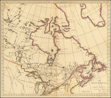
English Edition of the First Official Map to Show the Initial European Encounter with Alaska
Fine example of the English edition of Gerhard Friedrich Müller's influential map of the Northwest Coast of America and the Northeast Coast of Asia. First published in 1754, the map was the earliest to show an outline of the Alaskan Peninsula.
The map was issued to counter the claims made by Joseph Nicolas De L’Isle, who had worked in Russia for decades before returning, or absconding, to France, and Philippe Buache. The two had issued a controversial map in June 1752 that claimed there was a vast inland sea—the Sea of the West—and trusted in the dubious reports of Admiral Fonte.
The map stretches from Nova Zembla to Baffin Bay, showing a huge swath of the North Pacific. It includes the outline of a large, conjectural landmass that approximates the peninsula and archipelago that today makes up western Alaska. It provides one of the best cartographic depictions of the Northwest Coast prior to the surveys of James Cook on his final voyage (1776-1780), based on the findings of the First and Second Kamchatka Expeditions (1728-1730, 1733-1743).
There are tracks of several ships in the frigid northern waters. These are the tracks of Bering, his second-in-command, Captain Alexsei Chirikov (Tchirikov), as well as a little-known 1648 voyage by Dezhnev that managed to round Kamchatka. Near Kamchatka is a double-dashed line that shows the exploration by Schestakow and Pawlutzki in the late 1720s, just after Bering’s First Kamchatka Expedition. On the Alaskan mainland is a “Coast Discover’d by Surveyor Gwosdew” in 1730; this was Mikhail Gvosdev, who supposedly led an expedition that confirmed Bering’s finding that there was a strait between the continents.
Interestingly, that waterway between Asia and North America is labeled as the Strait of Anian, “of the Ancient Geographers.” The rumor of this strait and a Northwest Passage in general inspired many voyages of discovery, including those of John Cabot, Sir Francis Drake, Gaspar Corte-Real, Jacques Cartier, and Sir Humphrey Gilbert. The term Anian itself comes from Marco Polo’s thirteenth-century accounts of his travels. Polo used the term to refer to the Gulf of Tonkin, but cartographers thought it could refer to this supposed strait between Asia and North America. The Strait of Anian, so named, first appeared in a 1562 map by Giacomo Gastaldi, and was later adopted by Bolognini Zaltieri, Gerard Mercator, and many others.
On the West Coast of North America several other navigators are mentioned. These include Sir Francis Drake, who landed in California during his piratical circumnavigation, the first for an Englishman (1577-1580). Farther north, three inlets mention three other navigators—Martin Aguilar, Juan de Fuca, and Admiral Fonte—whose findings were still under suspicion and are therefore mentioned, yet downplayed, on this map.
Juan de Fuca is the Castilianized name of Greek navigator Ioánnis Fokás (Phokás). Little archival evidence survives of Fuca's career, but a chance meeting with an English financier, Michael Lok, in Venice in 1596 gave birth to rumors of Fuca's voyages in the Pacific. Fuca reported that he had been sent north from New Spain twice in 1592 in search of the Strait of Anian. The Spanish Crown failed to reward Fuca's discovery of an opening in the coast at roughly 47° N latitude and Fuca left the Spanish service embittered. His story lived on in Lok's letters and eventually was published in Samuel Purchas' travel collection of 1625. In 1787, the present-day Juan de Fuca Strait was named by the wife of naval explorer Charles William Barkley, making permanent a label that had previously just been hopeful conjecture.
Aguilar was a Spanish captain who sailed with Sebastian Vizcaino on a reconnaissance expedition up the California coast in 1602-3. Aguilar, commanding the Tres Reyes, was blown off course, to the north. When the seas calmed, Aguilar reported that he had found the mouth of a large river. Some eighteenth-century geographers conjectured that the river was the entrance to the Sea of the West, although here Müller instead has it as the mouth of a River of the West. This river is one of the most notable features on the map. It connects from the Pacific to Hudson’s Bay and offers a strong suggestion of a navigable Northwest Passage. Whereas Müller had abandoned the grandiose Sea of the West that appeared on Buache and De L’Isle’s 1752 map (and their later maps), he has kept the idea of an inland waterway that could connect Atlantic and Pacific.
Müller, De L’Isle, and Buache—a cartographic controversy
Joseph Nicholas De L'Isle spent much of his career in Russia, where he helped to found the Russian Academy of Sciences. While there, he had access to the latest findings of Russian explorers and was at the center of Russia's geographic establishment; for example, he helped produce the first Russian atlas, the Atlas Russicus, with Ivan Kyrilov.
De L’Isle was not the only foreign savant attracted to the Russian Court. Gerhard Friedrich Müller was a German linguist and historian. He also helped to found the Academy of Sciences at St. Petersburg, where he taught Latin and geography. He also recruited across Western Europe on behalf of the Academy, and served as its Secretary. Skilled at research and a keen observer, Müller was a member of Bering’s Second Kamchatka Expedition, working in Siberia to compile a pioneering ethnography of the area.
De L’Isle returned to Paris in 1747 with a large map collection, an event that drew some criticism from Russian academicians who thought he had absconded with delicate materials. One of these academicians was Müller, who had served as the translator between Bering and De L’Isle when they met before the departure of the Second Kamchatka Expedition, for which De L’Isle prepared maps and materials.
Müller was not only scandalized that De L’Isle had taken sensitive documents, but that the De L’Isle-Buache map of June 1752 was so erroneous. In an anonymous pamphlet published first in French in 1753 and then translated into German and English, Müller represented himself as a Russian Sea Officer (he was neither Russian nor a naval officer). The Officer explained that De L’Isle had not reviewed all the journals from the expedition and therefore made mistakes, specifically in the truncated tracks of Bering’s ship and the inclusion of strange lands at 75°N. Müller was also annoyed that De L’Isle had not shared letters in his possession about the discoveries of one Admiral de la Fonte.
On the 1752 map, a Lac de Fonte is connected to a series of lakes and a Rio de los Reyes. Admiral de Fonte supposedly sailed to the area in the mid-seventeenth century. The first mention of Fonte appears in two letters published in London in 1708 in two issues of The Monthly Miscellany or Memoirs for the Curious. The Fonte letters had been reprinted by Arthur Dobbs in his 1744 An Account of the Countries adjoining Hudson's Bay and were mentioned in other travel accounts. De L'Isle's copy of the letters came from Lord Forbes, British ambassador to Russia, as he explained in a memoir, Nouvelles Cartes des Decouvertes de l'Amiral de Fonte (Paris, 1753). He also read of them in Henry Ellis' account of the 1746-7 expedition to Wager Inlet.
The letters recounted that Fonte had found an inlet near 53°N which led to a series of lakes. While sailing northeast, Fonte eventually met with a Boston merchant ship, commanded by a Captain Shapley. One of Fonte's captains, separated from the Admiral, reported he had found no strait between the Pacific and the Davis Straits, yet had reached 79°N, helped by local indigenous peoples. This story, with its suggestion of water passages connecting the Pacific Northwest with the east, inspired hope in some and doubt in others in the mid-eighteenth century. A few, like Irish mapmaker John Green, thought the entire story a farce. Many, including De L'Isle and Buache, thought the information conformed neatly to other recent discoveries and included Fonte on their map.
Between writing his pamphlet as a Russian Sea Officer in 1752 and releasing this map in 1754, Müller seems to have reviewed the evidence and decided to minimize Fonte’s presence. His name is only shown near an opening in the coastline, and Fonte has a “pretended” journal, that is “according to Mr. de Lisle.” Müller’s skepticism is evident.
In addition to skepticism, Müller was modest about his map, “My work herein has been no more than to connect together, according to probability, by points, the coasts that had been seen in various places” (as quoted in Williams, 262). Modesty aside, however, Müller’s map is a landmark of Alaskan cartography and is part of an important story in the European exploration of the North Pacific.
Müller’s map first appeared in French in 1754, with an updated state in 1758, which was published alongside his account of the Bering voyages in the third volume of his general history of Russia. The accounts were translated into English in 1761 and published, along with this map, by Thomas Jefferys in 1761 and again in 1764. Jefferys also later included it in his American Atlas. This map closely resembles Müller’s 1758 state, with a simpler cartouche and the addition of a key in the bottom left and additional tracks in the “Sea of Ochozk.”
Robert Sayer (ca. 1724-1794) was a prominent London map publisher. Robert’s father was a lawyer, but his older brother married Mary Overton, the widow of prominent mapmaker Philip Overton and the proprietor of his shop after his death. Mary continued the business for roughly a year after her marriage and then, in early 1748, it passed to Robert. Robert became a freeman of the Stationers’ Company later that year; his first advertisement as an independent publisher was released in December.
Sayer benefited from Overton’s considerable stock, which included the plates of John Senex. In the 1750s, Sayer specialized in design books and topographical prints, as well as comic mezzotints. In 1753, he, along with John Roque, published a new edition of Thomas Read’s Small British Atlas, the first of several county atlases that Sayer would publish.
Sayer’s business continued to grow. In 1760 he moved further down Fleet Street to larger premises at 53 Fleet Street. In 1766, he acquired Thomas Jefferys’ stock when the latter went bankrupt. In 1774, he entered into a partnership with John Bennett, his former apprentice. The pair specialized in American atlases, based on the work of Jefferys. They also began publishing navigational charts in the 1780s and quickly became the largest supplier of British charts in the trade.
Bennett’s mental health declined, and the partnership ended in 1784. As Sayer aged, he relied on his employees Robert Laurie and James Whittle, who eventually succeeded him. He spent more and more time at his house in Richmond. In 1794, he died in Bath.
![[ Ottawa ] City of Ottawa Canada West](https://storage.googleapis.com/raremaps/img/small/74782.jpg)
![[ Exceptional original hand-color with highlights in gold ] Typus Aspectuum Oppositionum Et Coniunctionum Etz In Planetis](https://storage.googleapis.com/raremaps/img/small/81866.jpg)
![[ Missionary Map ] Canada Carte Indiquant Les Limites Des Dioceses, etc. Catholiques Romains Par G. Baillairge Ex-depute-ministre des Treavaux Publics de Canada 1893.](https://storage.googleapis.com/raremaps/img/small/37899.jpg)