|
||

|

|
|

|
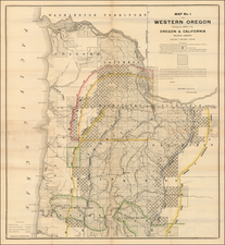
Rare early edition of Mitchell's map of the West, one of two post-1849 editions that predates the formation of Washington Territory.
The Bartlett and Graham Lines are shown, pre-dating the Gadsden purchase. Kearney's Route is shown, as is the Spanish Trail from Santa Fe to Los Angeles. The Oregon Route is also shown, as is Fremont's route and Cook's wagon route. Many early forts and Indian tribes appear. The boundary of 1819 with Spain is also shown, which pre-dated California's annexation into the US. The map includes a massive Tule Lake and no sign of Lake Tahoe.
This map is technically the last of the 1846-1849 series, which extends only to the Rocky Mountains. In the next known edition of this map, the map would be completely re-engraved, with the new plate extending further east of the Rocky Mountains, to incorporate most of Colorado (then still Indian Territory). Currently, the map stops just at the Three Parks.
While the title is the same as the 1850 edition, this edition is differentiated by the addition of an imprint line below the map. In this edition, no counties are shown, and would only come in subsequent editions.
![[Drake's Bay to Fort Bragg] Bodega Head to Abalone Point From The Latest United States Government Charts . . .](https://storage.googleapis.com/raremaps/img/small/73078.jpg)
![[ Jackson Hole and Environs ] Geological Map of Portions of Wyoming, Idaho and Utah](https://storage.googleapis.com/raremaps/img/small/97191.jpg)
![[Geology Map of the Texas, California & the Southwest] Esquisse Geologique Des Anciennes Possessions Mexicains Du Nord Incorporees Ala Federation des Etats-Unis . . . 1867](https://storage.googleapis.com/raremaps/img/small/71446.jpg)