|
||

|

|
|

|
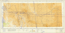
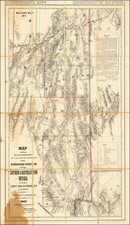
Monumental 2 sheet topographic map of Grand Canyon National Park, published by the US Geological Survey.
This stunning large format map of the Grand Canyon National Park, Arizona, was first printed in 1927 edition, based on surveys from 1902 to 1923 by François E. Matthes and Richard T. Evans. It is scaled at 1:6000 with a contour interval of 50 feet, and adjustments to the datum are indicated to ensure accuracy.
The map's use of polyconic projection and its adjustment for North American datum are consistent with cartographic practices of the early 20th century, designed to provide precise topographical detail for navigational and geological purposes. The instructions for adjusting elevations by decreasing them by four feet reflect changes in measuring standards over time.
As a historical document, this map offers insight into the methods of surveying and map-making during a period when such activities were critical for exploration and the subsequent development of national parks. The map’s utility is rooted in its ability to convey the complex terrain of the Grand Canyon accurately, an essential feature for both historical and contemporary users.
For scholars and enthusiasts of cartography and American history, this map serves as a record of the Grand Canyon's topography as understood in the early 20th century. It encapsulates the state of geographic knowledge of the time and provides a reference point for changes in the landscape and mapping technology.
This topographic map is a scholarly resource that reflects the systematic documentation of one of the United States’ most significant natural landmarks. Its reprinted status in 1948 indicates its continued relevance and the longevity of the information it presents.