|
||

|

|
|

|
Stock# 100814
Description
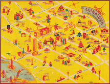
Scarce Don Bloodgood pictorial map of the Navajo Nation, published for the Navajo Tribal Council.
The map depicts the Navajo Lands of Northeastern Arizona and bounded in the west by the Little Colorado River, Grand Canyon, Flagstaff, and Lake Powell to Shiprock and Gallup, New Mexico.
Lots of mining lands, trading posts, and western topography, overlaid with a whimsical touristy pictorial style characteristic of Bloodgood's work.
The map provides a remarkable and colorful image of the region.
![[ Southern California Water Explorations ] Topographical Sketch showing the Outward and Inward Route of A Party, while examining the practicability of a Diversion of the Colorado River for Purposes of Irrigation under the Command of 1st Lieut. Eric Bergland Corps of Engineers, U.S. Army 1875](https://storage.googleapis.com/raremaps/img/small/98208.jpg)