|
||

|

|
|

|
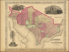
Washington Before the National Mall
A fine statistical map of Washington D.C. done by Lt. Francis Vinton Greene of the U.S. Army Corps of Engineers in 1882. The street plan and layout of D.C. is elegantly illustrated, featuring notable roads like Pennsylvania Avenue and depictions of the White House and the Capitol Rotunda. Signs of a bygone age are also present on the map such as Analostan Island (now Theodore Roosevelt Island) and the Baltimore & Ohio Railroad that connected the city to the rest of the country.
The map's standout feature is the vivid contemporary hand-coloring of the streets of D.C. As this is a statistical map, its primary aim is to illustrate information, in this case, the composition of the city's streets. Street quality appears to vary widely throughout Washington with some streets paved with gravel or wood while others are granite or cobblestone. A large section of the streets are unimproved or asphalt, illustrating an interesting disparity between the central governmental area and the larger residential city. Each street material is assigned a color which creates an eye-catching depiction of 1880s Washington.
This chart is the third statistical map in a series done by Greene and the Corps of Engineers throughout the late 19th century. Prior charts recorded the valuation of real estate property, placements of trees, gas lamps, and water mains, and the development of schools, street cars, and telegraph lines. A full series of these maps can be viewed from the Library of Congress's website.
![Preliminary Chart of the Potomac River (in four sheets) Sheet No. 1 From Entrance to Piney Point [with] Sheet No. 2 From Piney Point to Lower Cedar Point [with] Sheet No. 3 From Lower Cedar Point to Indian Head [with] Sheet No. 4 From indian Head to Little Falls Bridge](https://storage.googleapis.com/raremaps/img/small/88214.jpg)
![[ Epidemiology Map ] Map of the City of Washington](https://storage.googleapis.com/raremaps/img/small/99287.jpg)