


|
||

|

|
|

|
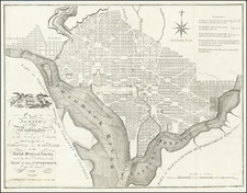
Rare German map of Washington DC, based upon Andrew Ellicott's plan, first published in 1792.
The map appeared in Zimmermann's rare Taschenbuch der Reisen...
Andrew Ellicott Plan of Washington, DC
Andrew Ellicott's Plan of Washington, was the first official map of the City of Washington, then the future capital of the United States.
The site of the permanent American capital remained unsettled for years after the United States gained its independence from Great Britain. Prior to 1790 Congress met variously at Philadelphia, Lancaster and York, Pennsylvania; Annapolis and Baltimore, Maryland; Princeton and Trenton, New Jersey; and New York City.
The location of the permanent capital was not confirmed until the Residence Act of 1790, which provided for a district not more than 10 miles square along the Potomac River, "at some place between the mouths of the Eastern Branch and the Connogocheague." Passage of the Act was made possible by the Compromise of 1790, in which southern states agreed to back Alexander Hamilton's plan for federal assumption of state debts in return for the latter's support for locating the capital along the Potomac.
In January 1791, President Washington announced that the capital district would be a diamond-shaped tract, 10 miles per side, roughly centered on the confluence of the Potomac and Eastern Branch (Anacostia) Rivers. Andrew Ellicott was engaged to conduct a topographical survey of the area, while Pierre L'Enfant was hired to develop a plan for the capital city itself. L'Enfant was a French artist and engineer who had served as a volunteer during the Revolution, and was sufficiently well connected that he had been asked to design the seal for the Society of the Cincinnati. He was brilliant but difficult, so much so that George Washington eventually fired him in 1792 and engaged Andrew Ellicott to complete the project. Ellicott, in turn, used L'Enfant's design as the basis for his plan of the city.
Upon completion of his drawings, Ellicott forwarded his manuscript plan to the firms of Thackara & Vallance in Philadelphia and Samuel Hill in Boston. Each firm was engaged to engrave and publish the plan as quickly as possible, in order that it might be distributed to facilitate the sale of land in the new city. Before publishing the large-scale "official" plans, each firm released smaller versions, which appeared as plates in The Universal Asylum And Columbian Magazine (Thackara & Vallance, published March 1792) and the Massachusetts Magazine (Hill, May 1792). The full size engraved versions of the large-scale, "official" plan were not ready until the summer of that year.
In subsequent years, it was copied a number of times in Europe and America for various publications.


![Preliminary Chart of the Potomac River (in four sheets) Sheet No. 1 From Entrance to Piney Point [with] Sheet No. 2 From Piney Point to Lower Cedar Point [with] Sheet No. 3 From Lower Cedar Point to Indian Head [with] Sheet No. 4 From indian Head to Little Falls Bridge](https://storage.googleapis.com/raremaps/img/small/88214.jpg)
![Maryland & Delaware and the District of Columbia [large Washington inset]](https://storage.googleapis.com/raremaps/img/small/100301.jpg)