|
||

|

|
|

|
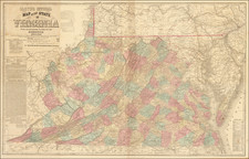
An American Rarity -- The First Large Scale Charting The Potomac From Washington DC to Chesapeake Bay
Monumental set of four separately published hydrographical charts of the Potomac River constituting one large mapping of the length of the river from its opening to Washington, D.C.
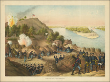
While the surveying project predated the Civil War (triangulation and hydrography started in 1860, while topography was started in 1858), the Potomac played an important enough strategic role during the Civil War that the completion of the mapping surely gained initial impetus from that event. Completed in the early part of the Civil War, the chart is a remarkably detailed and comprehensive treatment of the River, including ferry points, lighthouses, buoys, soundings, fortifications, waterfront railroad depots and rail lines. In aggregate, the map stretches to about 10 feet wide by 5 feet tall, providing a meticulous image of the river and its environs.
The chart even includes the dock, roads and buildings at Mount Vernon, George Washington's long time home.
Later examples were issued in 1864 and 1868 in reduced sizes.
Rarity
The original complete 1862 set of four charts is very rare. OCLC locates 3 copies (Library of Congress, Pennsylvania State Library and University of Virginia).
AMPR locates 1 example in a dealer catalog (High Ridge Books, 1997).
The United States Office of the Coast Survey began in 1807, when Thomas Jefferson founded the Survey of the Coast. However, the fledgling office was plagued by the War of 1812 and disagreements over whether it should be civilian or military controlled. The entity was re-founded in 1832 with Ferdinand Rudolph Hassler as its superintendent. Although a civilian agency, many military officers served the office; army officers tended to perform the topographic surveys, while naval officers conducted the hydrographic work.
The Survey’s history was greatly affected by larger events in American history. During the Civil War, while the agency was led by Alexander Dallas Bache (Benjamin Franklin’s grandson), the Survey provided the Union army with charts. Survey personnel accompanied blockading squadrons in the field, making new charts in the process.
After the Civil War, as the country was settled, the Coast Survey sent parties to make new maps, employing scientists and naturalists like John Muir and Louis Agassiz in the process. By 1926, the Survey expanded their purview further to include aeronautical charts. During the Great Depression, the Coast Survey employed over 10,000 people and in the Second World War the office oversaw the production of 100 million maps for the Allies. Since 1970, the Coastal and Geodetic Survey has formed part of the National Oceanic and Atmospheric Administration (NOAA) and it is still producing navigational products and services today.