|
||

|

|
|

|
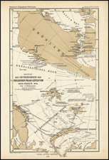
The map presents the geographical discoveries made by the British Arctic Expedition led by Sir George Nares aboard HMS Alert and Discovery from 1875 to 1876. Issued by Augustus Petermann, the map delineates with remarkable precision the contours and inlets of uncharted Arctic territories, capturing the furthest northern navigations of its time.
In the late 19th century, the British Empire sought to expand its knowledge and territorial claims in the Arctic region. Sir George Nares, an esteemed naval officer and explorer, was entrusted with leading this daring expedition. Their voyage, meticulously charted on this map, was a considerable undertaking during the age of exploration. It not only sought new passages but also aimed to reach the North Pole, a feat not achieved at that time.
The map is a testament to the intrepid spirit of the era, illustrating the British expedition's routes through perilous ice and harsh climates. It reflects the intricate network of the newly discovered coastlines and named landmarks such as "Grant Land" and "Smith Sound," honoring patrons and figures relevant to the mission and the Royal Navy. The place names bear witness to the trials, tribulations, and triumphs of this bold voyage.
Sir George Nares's role as an Arctic explorer is chronicled through the exacting details of this map. His leadership in negotiating the treacherous Arctic waters and his decision to prioritize the safety of his crew over the pursuit of glory demonstrate his prudent and skillful command. This map not only delineates geographic features but also marks a significant chapter in the history of Arctic exploration.
August Heinrich Petermann (1822-1878) is a renowned German cartographer of the nineteenth century. Petermann studied cartography at the Geographical Art-School in Potsdam before traveling to Edinburgh to work with Dr. A. Keith Johnston on an English edition of Berghaus’ Physical Atlas. Two years later he moved to London, where he made maps and advised exploratory expeditions as they set off to explore the interior of Africa and the Arctic.
In 1854, Petermann returned to Germany to be Director of the Geographical Institute of Justus Perthes in Gotha. There, he was the editor of the Geographische Mittheilungen and Stieler’s Handatlas. The Royal Geographical Society of London awarded him their Gold Medal in 1860. He continued his interest in exploration in Germany, fundraising for the German Exploring Expeditions of 1868 and 1869-70, which sought an open Arctic sea. Tragically, he committed suicide in 1878.
![[ World in Two Hemispheres on Polar Projections ]](https://storage.googleapis.com/raremaps/img/small/99920.jpg)