|
||

|

|
|

|
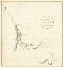
"The First Thematic Map of the World By An American" (Nebenzahl)
John Churchman (1753-1805), an esteemed American mathematician, surveyor, and mapmaker, is notably recognized for his innovative contributions to cartography. Churchman, who also served as the official surveyor for several counties in Pennsylvania, initially gained recognition with his 1778 "Map of the Peninsula between Delaware & Chesapeak Bays." His commitment to geographical sciences and his ambition to solve the longstanding problem of determining longitude at sea distinguished him in the scientific community of the late 18th century.
Churchman's fascination with the problem of maritime longitude, a challenge that had perplexed navigators and scientists for centuries, led him to develop a unique theory. He hypothesized that by precisely locating the northern and southern magnetic poles and understanding the consistent rotation of these poles around the geographic poles, one could accurately determine longitude. This approach, while theoretically novel, was flawed in practice due to unpredictable changes in the magnetic poles' positions and the difficulty of measuring magnetic variation at sea.
Despite these shortcomings, Churchman actively promoted his methods to prominent figures such as Benjamin Franklin, Thomas Jefferson, and Joseph Banks, and to esteemed institutions like the American Philosophical Society and the Royal Academy of Sciences in France. His correspondence, particularly with Thomas Jefferson, reveals the contemporary scientific community's mixed reactions to his theories.
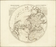
In 1790, Churchman published "The Magnetic Atlas," which was followed by an expanded edition featuring newly engraved maps of the northern and southern hemispheres in 1794. A third edition was issued in New York in 1800, with significant updates, including comprehensive chapters on magnetic discoveries, the construction and usage of the Magnetic Atlas, and Churchman's speculations on magnetic variation.
The first London edition, published in 1794, was described by Nebenzahl as:
This London issue is the definitive edition. The first, preliminary issue of Philadelphia was an octavo with half the pages and contained a chart of only the northern hemisphere.
Churchman received considerable encouragement from men like Jefferson, Joseph Banks, Washington, and Concorcet (whose testimonials are printed in the book). Jefferson, while expressing a small doubt about the system, wrote, "I shall be happy that our country may have the honour of furnishing the old world with what it has so long sought in vain."
Had Churchman's theory proven out, it would have been one of the earliest and most important American contributions to science. His double-hemispheric, polar projection map in this book, which shows compass variations, is the first thematic map of the world by an American.
A second London edition would be published in 1804, with significant additional improvements to the text and maps.