|
||

|

|
|

|
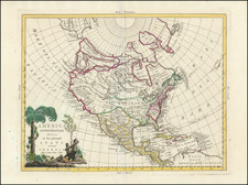
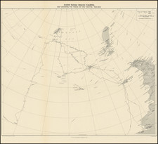
Fascinating study of the prevailing theories regarding the Northeast Coast of Asia during the second half of the 18th Century, prepared by Diderot.
The 10 maps which accompany the supplement to Diderot's Encyclopedia are one of the earliest studies of comparative cartography, compiling the most modern variant theories and setting them out side by side or in a series of maps.
This set of 3 maps focuses on the 3 theories of the NE Coast of Asia as reported by various German & Russian explorers. The NE Passage is the focal point of this map, contrasting the reports of three 18th Century cartographers. Gorgeous full color example.
Didier Robert de Vaugondy (ca. 1723-1786) was the son of prominent geographer Gilles Robert de Vaugondy and Didier carried on his father’s impressive work. Together, they published their best-known work, the Atlas Universel (1757). The atlas took fifteen years to create and was released in a folio and ¾ folio edition; both are rare and highly sought-after today. Together and individually, father and son were known for their exactitude and depth of research.
Like his father, Didier served as geographer to King Louis XV. He was especially recognized for his skills in globe making; for example, a pair of his globes made for the Marquise de Pompadour are today in the collection of the Municipal Museum of Chartres. Didier was also the geographer to the Duke of Lorraine. In 1773, he was appointed royal censor in charge of monitoring the information published in geography texts, navigational tracts, and travel accounts.
The Robert De Vaugondy Family
Gilles Robert de Vaugondy (1688-1766) and Didier Robert de Vaugondy (1723-1786) were influential figures in the realm of 18th-century French cartography. Originating from Paris, their contributions to mapmaking were significant during an era of expansive geographical exploration.
Gilles Robert de Vaugondy entered the world of cartography not through family tradition but through personal interest and the budding opportunities of his time. Born in 1688, he worked during a time when Paris was becoming a central hub for cartographic activities. Gilles often incorporated the latest findings from explorers into his maps, making them sought-after for their contemporary relevance. His connections weren't limited to his immediate circle; he frequently interacted with other key mapmakers, staying updated on the latest techniques and findings.
His son, Didier, was born in 1723 and had the advantage of growing up surrounded by maps and globes. While his father was renowned for maps, Didier made a name for himself in the field of globemaking. His globes were some of the most precise and detailed in France, gaining recognition even among the royalty. In addition to his work in cartography and globemaking, Didier had a keen interest in education, especially after the expulsion of the Jesuits from France. He stepped in to produce geographical educational materials, fulfilling a newfound need.
In terms of predecessors, the Vaugondys followed in the footsteps of notable French cartographers like Nicolas Sanson and Guillaume Delisle. The latter was particularly influential during the early 18th century, setting high standards in scientific cartography. As for competitors, the Vaugondys were contemporaries with Jean-Baptiste Bourguignon d'Anville, a cartographer who, like them, was rigorous in his methodologies and had a significant influence on mapmaking during the same period.
The maps and globes produced by the Vaugondys remain an enduring testament to the peak of French cartography during the Enlightenment. Their works, characterized by precision and the inclusion of contemporary findings, helped to shape our understanding of the world during a transformative period in European history.
![[ Northeastern Nepal ] Tamba Kosi-Likhu Khola](https://storage.googleapis.com/raremaps/img/small/95927.jpg)
![[Signed Political Satire Artwork] Vietnam ... Vietnam ... Vietnam ...](https://storage.googleapis.com/raremaps/img/small/68726.jpg)