|
||

|

|
|

|
Stock# 98470
Description
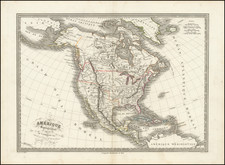
Scarce map of North America, published shortly prior to Texan Independence.
The map shows a 54-40 or fight boundary in the Pacific Northwest, showing the American claims extending far north of its final border as agreed between the US and Britain a decade later.
Upper California is crossed with a number of mythical rivers, running from Lake Timpanagos to Lake Teguayo to the Pacific Ocean via the Rio los Mongos, S. Sacramento, and sevearl unnamed rives.
The map illustrates a massive Oregon Territory, showing the hydrography largely based on Lewis & Clark. A number of Native American Tribes are located.
Alaska is Russian America.
Rarity
This is the first time we have seen this map.
![[Fruit Crate Label Advertising Map] Panama Brand (North America & Panama Canal)](https://storage.googleapis.com/raremaps/img/small/48860.jpg)

![A New Mapp of America Septentrionale . . . 1669 [California shown as an island]](https://storage.googleapis.com/raremaps/img/small/94304.jpg)
![[Revolutionary War Plans of New York, Boston, Charleston, Delaware River to Philadelphia & Havana] Various Plans and Draughts of Cities, Towns, Harbours &c . . .](https://storage.googleapis.com/raremaps/img/small/83450.jpg)