|
||

|

|
|

|
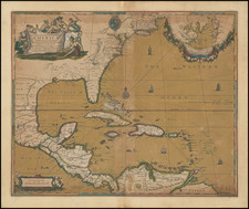
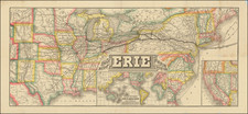
The Birth of Washington Territory and the "Territory of Nebraska as Proposed"
Fine wall map of the United States showing the states and territories of the newly conquered American Southwest, in the months before the Gadsden Purchase / Treaty of La Mesilla of December 30, 1853.
Monk's map was issued over a series of years, with significant territorial and other changes each year. This 1853 edition is noteworthy as the first to shown Washington Territory and the "Territory of Nebraska as Proposed" a curious pre-Kansas–Nebraska Act of 1854 configuration which attempted to anticipate the new territory's boundary.
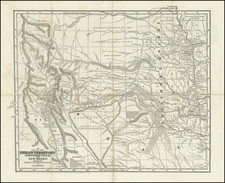
The detail on the American West is finest in the "Gold Region," which shows a mass of diggings, settlements, and other geography extending from the crest of the Sierra Nevada to the San Joaquin and Sacramento Rivers. The Utah Territory extends from Long's Peak to the Sierra Nevada, with the Mormon settlements noted in the vicinity of the Great Salt Lake.
This 1853 edition is the first edition to show Washington Territory, separated from Oregon Territory, with just a few early settlements in Washington Territory, including Pacific City, Fort Walla Walla, and a few missions.
This 1853 edition is also the first to show the "Nebraska Territory as Proposed", as well as well as a new area to the north labeled "Indian Territory". The territory would be radically reconfigured to become Nebraska Territory extending to the Canadian Border with Kansas Territory below, as part of the Kansas–Nebraska Act of 1854.
The map is also the first state to show the radical reconfiguration of the Colorado River and its Tributary sources, including the Virgin River and San Juan River, as a result of the ongoing American Surveys in the west.
Texas is shown in fine detail, with the Fisher & Miller Colony and "German Settlements" upriver of Austin, a coal bed near the headwaters of the Nueces River, and the cross-timbers depicted pictorially. Further north, along the Santa Fe Trail, a curious "Fan Land District" is shown.
The map is filled with the name of Native American nations, many of which have unusual phonetically spellings.
The explorations of Pope and Nicollet are reflected in the newly formed Minnesota Territory and the Hydrographical Basin of the Mississippi River. The treatment of Mexican geography is slightly sparser.
Wheat terms the map "showy," likely referring to the many decorative elements including the mid-18th-century ships throughout the oceans. An inset world map appears in the lower left, with early colonies appearing in Africa. A list of all the counties and county towns in the United States can be found to the right. The map also includes a table of distances.
Jacob Monk's maps of North America were perhaps the single most popular series of large-format maps of North America published in the 1850s. Monk's map was first issued in 1852 and was updated several times a year for the better part of a decade. As one of the most widely distributed wall maps of the United States from the 1850s, it is a map that defined Americans' vision of the West.