|
||

|

|
|

|
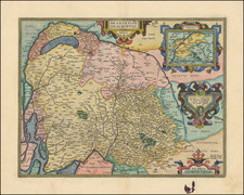
Striking example of Gerard Mercator's detailed map of Zeeland, first published in Duisburg in 1595.
Includes an elaborate strapwork cartouche and sailing ships.
The geopolitical situation of Zeeland, a key province in the Netherlands, during the final two decades of the 16th century was profoundly shaped by the Eighty Years' War (1568–1648), a seminal conflict in the history of Western Europe. This period, spanning the 1580s and 1590s, was marked by intense military, political, and religious upheavals, which played a pivotal role in shaping the region's destiny.
In the late 16th century, the Netherlands, including Zeeland, was engulfed in the throes of the Dutch Revolt against the Spanish Habsburg rule. This revolt was not merely a struggle for political autonomy but also a battle for religious freedom, as the Protestant Reformation had taken a strong hold in the region, in opposition to the Catholic Spanish monarchy. Zeeland, with its strategic maritime position, emerged as a crucial theater of conflict in this larger continental drama.
The strategic importance of Zeeland was underscored by its location. As a coastal province with significant access to the North Sea, Zeeland was a vital node in the control of trade routes and military operations. This maritime significance was exemplified in the Battle of the Spanish Armada in 1588, where the Dutch, along with the English, successfully repelled the Spanish fleet, marking a turning point in the war. Zeeland's ports, such as Flushing (Vlissingen), were pivotal in these maritime confrontations.
Politically, the period saw Zeeland actively participating in the Union of Utrecht (1579), a confederation of Dutch provinces that declared independence from Spanish rule. This declaration, known as the Act of Abjuration (1581), was a landmark moment in Dutch history, setting the stage for the emergence of the Dutch Republic. Zeeland's involvement in the Union underlined its commitment to the broader Dutch struggle for sovereignty and religious liberty.
Gerard Mercator is one of the most famous cartographers of all time. Mercator was born in Flanders and educated at the Catholic University in Leuven. After his graduation in 1532, Mercator worked with Gemma Frisius, a prominent mathematician, and Gaspar a Myrica, a goldsmith and engraver. Together, these men produced globes and scientific instruments, allowing Mercator to hone his skills.
With his wife, Barbara, Mercator had six children: Arnold, Emerentia, Dorothes, Bartholomeus, Rumold, and Catharina. In 1552, Mercator moved to Duisburg from Leuven, where he lived for the rest of his life. In 1564, he was appointed the official cosmographer to the court of Duke Wilhelm of Cleve.
Mercator’s most important contribution was the creation and popularization of a projection which now bears his name. On Mercator projection maps, all parallels and meridians are drawn at right angles to each other, with the distance between the parallels extending towards the poles. This allowed for accurate latitude and longitude calculation and also allowed navigational routes to be drawn using straight lines, a huge advantage for sailors as this allowed them to plot courses without constant recourse to adjusting compass readings.
Mercator’s other enduring contribution to cartography is the term “atlas”, which was first used to describe his collection of maps gathered in one volume. The Mercator atlas was published in 1595, a year after Mercator’s death, thanks to the work of his sons, particularly Rumold, and his grandsons.
![(France) Gallia Antiqua Ex Aevi Romani Monumentis Eruta et Serenissimi Carnutum Ducis Munificentia Publici Juris Facta [Ancient Gaul From the Roman Age, the erudite Monuments. . .]](https://storage.googleapis.com/raremaps/img/small/82019.jpg)
![[Composite Lafreri-style Atlas of Battle Plans and Fortifications]](https://storage.googleapis.com/raremaps/img/small/92702.jpg)