|
||

|

|
|

|
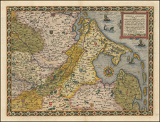
Map of Ancient Gaul, showing France, the Low Countries, western Switzerland, and the Cologne region of Germany, divided into seventeen provinces.
The map details the provinces, Roman roads and imporant cities in Ancient Gaul.
Particular detail is given to the ancient Roman provinces of what is now modern-day France and environs. These 17 provinces, each denoted by a Roman numeral, provide a glimpse into the geographical divisions of the Roman rule over Gaul. Each of these provinces have their own unique history and characteristics:
-
Narbonensis Prima (I): This was located in Southern France, and was the first province to be conquered by the Romans. Its capital was Narbo Martius (modern-day Narbonne), a vital commercial port during the Roman Empire.
-
Viennensis (II): This province, with its capital at Vienna (modern Vienne), comprised parts of the French Alps and the Rhone valley. It was known for its prosperous agriculture and mineral resources.
-
Narbonensis Secunda (III): This province was further inland than Narbonensis Prima, yet it shared the same vital Roman road, Via Domitia.
-
Alpes Maritimae (IV): Located in the southeast of France, this region extended from the Mediterranean coast to the Maritime Alps.
-
Alpes Graiae et Pennina (V): This province covered the regions of the Graian and Pennine Alps, providing a significant mountainous barrier between Gaul and Italy.
-
Aquitania Prima (VI): Located in southwestern France, this region was particularly famous for its fertile lands and was considered a significant breadbasket for Rome.
-
Aquitania Secunda (VII): This province, sharing similarities with Aquitania Prima, was located further inland.
-
Novempopulana (VIII): This province covered the land of the Nine Peoples, in what is now Gascony and parts of Aquitaine.
-
Lugdunensis Prima (IX): Based around its capital Lugdunum (modern Lyon), this province was the center of Roman Gaul.
-
Lugdunensis Secunda (X): This province was located to the north of Lugdunensis Prima, along the Seine River, comprising the present-day region of Normandy.
-
Lugdunensis Tertia (XI): This was located to the west of Lugdunensis Prima, in what is now the western part of Central France.
-
Lugdunensis Quarta or Senonia (XII): This province stretched between the Seine and Loire rivers, with its capital in Sens.
-
Belgica Prima (XIII): Located in the northeastern region, this province included areas that are now part of Belgium and Luxembourg.
-
Belgica Secunda (XIV): This province was located to the west of Belgica Prima, stretching to the English Channel.
-
Germania Superior or Prima (XV): Covering the regions along the Rhine, this province included areas that are now part of Switzerland and Germany.
-
Germania Inferior or Secunda (XVI): This province extended along the lower course of the Rhine River, including parts of the Netherlands, Belgium, and Germany.
-
Maxima Sequanorum (XVII): This province was situated in the eastern part of France, comprising the region of Franche-Comté and parts of Burgundy.
Each of these provinces represented on the map provides a vivid representation of Roman Gaul. Studying the map gives us a unique perspective on how the Roman Empire influenced the geographical, cultural, and administrative landscape of what we now recognize as France.
The map also illustrates the remarkable network of roads spanning the whole of the Roman Empire, connecting remote regions to the heart of Rome. In Gaul, these roads formed the backbone of the provinces and were essential to the functioning and control of this crucial part of the Empire.
Roman roads were strategically constructed for military, administrative, and commercial purposes, establishing rapid and reliable routes for armies, officials, merchants, and even private travelers. These roads were ingeniously engineered, with multiple layers of materials for durability, and were typically straight to allow for efficient travel.
Some of the most notable Roman roads in Gaul included the Via Domitia, Via Agrippa, and Via Aurelia. The Via Domitia connected Italy to Spain by way of Gaul, creating a vital link between Rome and its territories. The Via Agrippa network, created by Marcus Agrippa, a close ally of Emperor Augustus, extended from Lugdunum (Lyon), the provincial capital of Gaul, to the northern and western frontiers of Gaul. Via Aurelia ran along the Mediterranean coast, connecting Rome to Arles in southern Gaul.
Major Roman cities sprang up along these roads, often at crucial junctions or crossings, and these cities played a critical role in maintaining the influence of Rome throughout the Empire. Many of these cities are still major urban centers today, reflecting the enduring influence of Rome.
Lugdunum (modern Lyon) was arguably the most important city in Roman Gaul. It was the capital of the three Gauls and a major hub of the Via Agrippa. The city was a significant administrative center, where the governors of Gaul resided and where the Gaulish council convened annually.
Narbo Martius (Narbonne) was another major city, serving as the capital of the province of Gallia Narbonensis. It was a crucial commercial center located on the Via Domitia, where goods from across the empire would pass through on their way to the Spanish provinces.
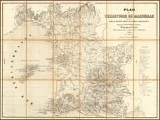
Massilia (Marseille) was one of the first Greek colonies in Gaul, and it flourished under Roman rule. Its location on the Mediterranean coast made it a significant port city.
Augustodunum (Autun) was an important administrative and educational center, boasting one of the Empire's finest public schools.
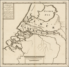
In the upper right corner, an inset illustrates the area of Batavia, located in the Rhine-Meuse river delta. Batavia was the land of the Batavi tribe during the Roman era. This ancient tribe was known for its fierce warriors and was a significant ally of the Roman Empire. The Batavi provided the Roman Empire with auxiliary forces, making crucial contributions to Rome's military exploits. The depiction of Batavia, with the convergence of Rhine and Meuse rivers, showcases the strategic significance of this location and offers a detailed glimpse into the Roman river-based trade and military navigation systems.
On the lower left, the second inset provides a detailed representation of Provence, a southeastern region of France. Provence has a significant place in Roman history, as it was one of the first Roman colonies in Gaul, known as 'Provincia Romana,' from which the modern name "Provence" is derived. The region was noted for its prosperity and cultural vibrancy during the Roman era, with the city of Massilia (modern Marseille) serving as a major port and trading hub. Furthermore, the region was known for its olive oil, wine, and a blend of Greek and Roman cultures. This detailed depiction of Provence helps to highlight the importance of the region during the Roman era and provides us with a closer look at its historical landscape.
Jean-Baptiste Bourguignon d’Anville (1697-1782) was one of the foremost French geographers of the eighteenth century. He carried out rigorous research in order to create his maps, which greatly developed the technical proficiency of mapmaking during his lifetime. His style was also simpler and less ornate than that of many of his predecessors. It was widely adopted by his contemporaries and successors.
The son of a tailor, d’Anville showed cartographic prowess from a young age; his first map, of Ancient Greece, was published when he was only fifteen years old. By twenty-two, he was appointed as one of the King’s géographes ordinaire de roi. He tutored the young Louis XV while in the service to the Crown. However, royal appointment did not pay all the bills, so d’Anville also did some work for the Portuguese Crown from 1724. For example, he helped to fill out Dom João V’s library with geographical works and made maps showing Portugal’s African colonies.
D’Anville disapproved of merely copying features from other maps, preferring instead to return to the texts upon which those maps were based to make his own depictions. This led him to embrace blank spaces for unknown areas and to reject names which were not supported by other sources. He also amassed a large personal map library and created a network of sources that included Jesuits in China and savants in Brazil. D’Anville’s historical approach to cartography resulted in magnificently detailed, yet modern and academic, maps. For example, his 1743 map of Italy improved upon all previous maps and included a memoir laying out his research and innovations. The geographer also specialized in ancient historical geography.
In 1773, d’Anville was named premier géographe de roi. In 1780, he ceded his considerable library to the Ministry of Foreign Affairs to be used for as a reference library for diplomats. D’Anville is best known for several maps, including his map of China, first published in 1735, and then included with Du Halde’s history of that country (the Hague, 1737). His map of Africa (1749) was used well into the nineteenth century.
![[Haarlem] Harlemum, sive ut Ha: Barlan Her:lemum Urbs Hollandia famosa . . .](https://storage.googleapis.com/raremaps/img/small/89288.jpg)