


|
||

|

|
|

|
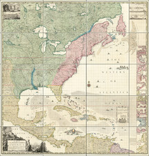
Rare Late State of The Finest Map of North America Published in America in the First Half of the 19th Century
Tanner's landmark map of North America, first issued in 1822, is perhaps the most important North American map of the 19th Century published in America.
Tanner's 1845 map includes several fascinating elements. The configuration of the Republic of Texas in noteworthy, a completely unique configuration, which is quite curious given that Tanner was the publisher of the Stephen F. Austin map of Texas from 1830 to 1848. Above Texas, the Ozark District, Osage District and Mandan Districts are shown, with a massive Iowa Territory and oversized Wisconsin Territory to the east.
The first state of the map includes several highly important "firsts" in the American Northwest, including
- first map to name Oregon Territory
- first map to show the 1821 Decree of Czar Alexander I, claiming the Northwest part of America north of 51 degrees.
As noted by James Walker:
Tanner’s [map] represents a significant placeholder in the early American literature on continental expansion of the republic to the West. The map was included in the fourth folio of Tanner’s New American Atlas, published in late 1822. A masterful summary of information derived from existing maps and travel and government documents, it is the first printed map to apply to the region the name “Oregon Terry." Tanner . . . likely adopted this toponym from Congressman John Floyd from Virginia, who introduced a bill in January 1822 to establish a “Territory of Origon” [sic] on the Pacific Coast.
. . . Tanner’s “Oregon Terry.” extends from the Missouri River to the Pacific Ocean, suggesting an American right of possession of transcontinental territory because of proximity both to the Columbia River and to regions east of the Rocky Mountains, where sovereignty already had been claimed or established. Tanner does not extend the 49th parallel boundary west of the Rocky Mountains, implying that the American territorial claims to the north were valid.
Tanner’s is the first map to name “Long’s Peak” and may be the first to identify the proposed Ukase (decree) of Tsar Alexander I of Russia in 1821, which claimed Russian sovereignty in the Pacific Northwest above latitude 51 degrees.
The map illustrates the extent of the discoveries of Lewis & Clark, and combines the information from the expeditions of Pike, James, and a host of other overland surveys, into this spectacular large format work. By 1845, the name was revised on the map to Oregon District, with the river systems an topography much improved from the earlier states.
While earlier states of the map included the two mythical rivers flowing from the area just west of the Rocky Mountains to the Pacific, draining the mythical lakes of Timpanogos and Teguayo, Tanner's map shows how a rudimentary understanding of the rivers which drain into the Sacramento Delta, but Lake Timpanogos remains, as does a greatly reduced size "Salt Lake".
Curiously, the R[iver] de los Martires remains, flowing across the mountains of Southern California into what looks like the San Luis Rey River.
The map was issued separately and also bound in four sheets into Tanner's New American Atlas, which was issued in serial subscription format and later as a bound volume, beginning in 1823.
Tanner's map is one of the milestones in American map making, both for its content and beauty.
Rarity
The 1845 state of the map is very rare. This is the second example we have seen in over 30 years.
![(Dallas, Texas) USAF Target Complex Mosaic-Series 25 [Sheets 0 - 4]](https://storage.googleapis.com/raremaps/img/small/87119.jpg)
![[ Early United States ] Etats Unis De L'Amerique](https://storage.googleapis.com/raremaps/img/small/98746.jpg)