


|
||

|

|
|

|
Stock# 87119
Description
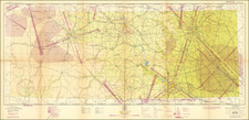
Impressive five-sheet aerial photograph maps of Dallas, Texas, based on photos taken in 1950 and published by the US Air Force in 1951.
The maps were prepared for the Strategic Air Command in 1951, possibly as part of an assessment of strategic targets during the early Cold War.
The map consists of five sheets, one for each quadrant of the Dallas metropolitan area, and one general sheet of central Dallas.
Condition Description
Five sheets, unjoined. Illustrated with a digital composite as the main image. Maps folding, as issued. Scant manuscript annotations.

![(Texas and California) The Whig Almanac and United States Register for 1843 [bound with:] The Whig Almanac and Politicians' Register for 1845 [bound with:] The Whig Almanac, and Politicians' Register for 1846 [with maps of Texas and Oregon] [bound with:] The Whig Almanac: 1847.](https://storage.googleapis.com/raremaps/img/small/87041.jpg)
![Carta geografica della Florida nell'America settentrionale [Geographical map of Florida in North America]](https://storage.googleapis.com/raremaps/img/small/84142.jpg)
![The North Coast of the Gulf of Mexico from St. Marks to Galveston . . . 1844 . . . Additions to 1856, including the Surveys of Comr. Powell, Lt. Simmes & Profr. Coffin, U.S. Navy [and] St. Marks to Galveston. Sheet II. . . . 1845. Additions to 1851 . . . .](https://storage.googleapis.com/raremaps/img/small/89497.jpg)