|
||

|

|
|

|
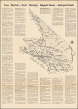
Published just after 1920 by the Clason Map Company in Denver, this comprehensive road map of California captures the state's intricate transportation landscape during the mid-1920s—a period marked by a significant surge in automobile usage and infrastructural development.
The map not only highlights main roads such as the Roosevelt National Trail, El Camino Real, and Pike’s Peak Ocean to Ocean Highway, but also catalogues various types of road surfaces, ranging from macadam and gravel to dirt and tar. Particularly arresting is the wooden 'planked road' traversing the desert expanses of Imperial County.
Additionally, the map is adorned with a wealth of other information. Inset maps of San Francisco and Los Angeles provide a focused examination of these burgeoning urban centers. County lines, county seats, railroads, trunk line railroads, Indian reservations, and National forests are all scrupulously delineated. Even steamship lines are featured, echoing California's multifaceted transportation history. Desert springs are specially highlighted in red, presumably to serve as vital reference points for early automobile travelers venturing across arid terrains.
The accompanying guidebook adds further nuance to the map. Detailed street plans of California’s urban centers are rendered alongside an extensive index of cities and towns. Together, the map and guidebook form a multifaceted representation of California's complex geography and advancing infrastructure.
![[ Exceptional original hand-color with highlights in gold ] Typus Aspectuum Oppositionum Et Coniunctionum Etz In Planetis](https://storage.googleapis.com/raremaps/img/small/81866.jpg)