|
||

|

|
|

|
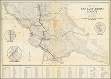
A Primary Source Map For The San Joaquin Valley in the Early 20th Century
Detailed map of San Joaquin County, published in the early part of the 20th Century.
Denny's map is a remarkable source for early details in the San Joaquin Valley at the outset of the automobile age, as modern roads were just being set and surveyed. For example, along the irrigation canals and creeks, the names of numerous local farmers can be seen and even the occasional pump. A number of rural schools are shown, as are small rural communities, many of which are not just "census" places or no longer exist on the map.
Denny's maps were the best commercially published county maps of California Counties. The present map includes:
- Roads
- Private Roads
- Railroads
- Electric Railroads
- Creeks and Ravines
- Canals
- County Boundary Lines
The present map has been annotated in red and black, showing what seems to be two different road classifications. Our guess is that "State Roads" are in black and "County Roads are in red."
Toward the top of the map, south of Galt and Forest Lake, is a dashed section crossing the Johant Slough. This is almost certainly showing the proposed course or progress of highway 99 north toward Sacramento, which would become the main artery for automobile transportation through the San Joaquin Valley.