|
||

|

|
|

|
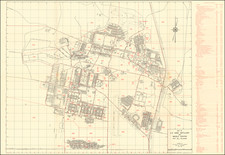
Map of U.S. Army Artillery and Missile Center Fort Sill, Oklahoma, prepared by the Office of the Post Engineer in July 1960 and revised in February 1962, provides a structured overview of Fort Sill's facilities and operations during the early 1960s. The map details specific building numbers alongside their corresponding functions, spanning from administrative centers such as the Adjutant General Personal Affairs Center to specialized departments and recreational facilities.
The 1960s represented a period of heightened military activity in the United States due to global geopolitical tensions, particularly the Cold War. Fort Sill, with its emphasis on artillery and missile training, held strategic importance in the broader framework of the U.S. Army. This map, with its delineation of various facilities and departments, offers a clear perspective on the organization and specialization of military bases during this time.
Additionally, the inclusion of a map of Lawton, Oklahoma, on the verso gives geographical context, drawing attention to the proximity and likely interactions between the military base and the neighboring town. Such a relationship is emblematic of the interconnectedness of military installations and their surrounding communities.
The range of departments and facilities listed on the map, from tactical operations like the Guided Missile Department to community-focused areas like the Bowling Alley, serves as an indicator of the diverse functions and daily operations on a military base in the mid-20th century. This map, in its detailed layout and annotations, offers a comprehensive view of Fort Sill's structure and priorities during a significant historical period.
![[ Through Cooperation to Communism ] Spolupraci ke Komunismu](https://storage.googleapis.com/raremaps/img/small/97646.jpg)
![[Original photograph] Native Americans, possibly Creeks, in outdoor camp with white settlers or Indian Agents.](https://storage.googleapis.com/raremaps/img/small/78740.jpg)