


|
||

|

|
|

|
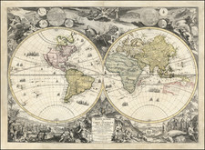
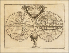
The Lost Paulus Ageminius Casket Map -- America Called Terra di Santa Croce
Fascinating late 18th Century engraved copy of the so called Paulus Ageminius Casket Map, a unique (and now lost) early copy of Bernardus Sylvanus's World Map of 1511.
Among the more fascinating elements of this map is the decision to call America TERRA S + (Terra di Santa Croce).
As noted by Rodney Shirley, "in the Trivulziana collection in Milan is an unusual metal casket of Italian origin which has a cordiform map of the world engraved in metal on the lid. It is signed Paulus Ageminius faciebat. The map is copied from Sylvanus’ map of 1511 and was probably engraved shortly after that date." The casket was damascened in gold, Silver, and other metals, in intricate Persian style patterns. On the top of the casket was a map of Italy, the Dalmatian coast, and Albania, all damascened in gold. Inside the lid were maps of France and Spain and on the bottom was a representation of the world. The casket was signed inside the lid Paulus Ageminius Faciebat, "agemina" being the particular form of damascene work used in this piece.
The author, Abbot Danielle Francesconi (1761-1835), from whose work the present printed version is derived, dated the casket to the mid-sixteenth Century and postulates a Venetian origin , where similar damascened works of art were made, notably by Paolo Rizzo, a goldsmith working in the Ruga di Orefici. Rizzo is traditionally assumed to be the maker of the remarkable Gatterburg-Morosini-Bardoc-Widener helmet, held in the National Gallery, Washington, D.C. , which feature s elaborate gold azzimina damascening. Francesconi tentatively identifies Paulus Ageminius with Paolo Rizzo and disputes the attribution of the casket to a Lombard artist , published by the Abbot of the Valentina, Mauro Boni, in Notizia di un a cassettin a geografic a (Venice 1800).
In 1970, Hans Huth wrote that the engraving by Paulus Ageminius was "presumably done for the goldsmith Paolo Rizzi whose workshop "At the Sign of the Dove" was at the Rialto. He must have been a native, for foreign craftsmen were not permitted by law to practice their art in the city. The style of the decoration of this piece, as of a group of similarly decorated caskets, cabinets, shields, picture frames, etc., clearly derives from Islamic damascened metalwork."
Subsequently, A.M. Massinelli opined that the casket was a forgery by Bonaventura Meneghetti.
Last recorded in the collection of Prince Trivulzio in Milan, the original casket is now lost, surviving only in this later engraved example by Daniele Francesconi's Illustrazione di un' urnetta lavorata di oro e di varii altri metalli all' agemina coll' iscrizione Paulus Ageminius faciebat, published in Venice in 1800.
The Sylvanus Map
Bernardus Sylvanus' pseudo-cordiform map of the modern world, published in Venice in 1511 is a map of landmark importance. The map is the second second atlas map of the World to show America, pre-dated only by the Johann Ruysch's map of 1507. It is also the earliest obtainable printed map to show and name the island of Japan.
Sylvanus' world map is one of the earliest obtainable maps of the world to include a portion of America, following the discovery of the New World by Columbus. Sylvanus's map is also the one of the earliest world maps printed in Venice and the first world map printed in two colors. A printing mistake in Asia, the duplication of the toponym "come" in both red and black, reveals that the color was added using separate registers.
In his dedication to Andreas Matheus Aquaevivus, Duke of Adria and Lord of Eboli, Sylvanus lamented that Ptolemy's charts were not reflective of modern sailors' experiences. Sylvanus constructed this world map as part of his attempt to reconcile and improve upon Ptolemy's version of the world, by integrating new information showing the world as Europeans were coming to know it at the beginning of the 16th Century.
The land masses are vigorously engraved with mountain ranges, rivers, and place names. The map is surrounded by a dozen decorative windheads and three signs of the zodiac: Cancer and Capricorn for the tropics and the scales of Libra representing the equator. The sides of the map are embellished with information on the climates with seven climates (represented as windheads) recorded above the equator and 4 below. Latitude runs from eighty degrees north to forty degrees south, while longitude is 320 degrees wide, although his numbering of longitude reveals that he thought there was more global space than he chose to show in this map.
Cartographic Features
Sylvanus' map integrates a considerable amount of modern information. The British Isles, the Indian Peninsula, and Africa all reflect the work of modern cartographers. Scotland is situated north of England and Wales, not extending horizontally east as in Ptolemy's maps. There is no strip of land connecting the southern part of Africa with Asia, making Africa circumnavigable.
Asia is a mixture of old and new. There remains a large peninsula in Southeast Asia, a holdover of Ptolemy's Afro-Asian bridge that made the Indian Ocean an insular sea. However, the islands "Java Minor" and "Java Maior" are products of the dissemination of Marco Polo's travels, making the region a synthesis of ancient and more recent sources of information. Due to a scribal error, the island of "Java Minor" was substituted for Champa, leading sixteenth century mapmakers to locate the lesser Java over a thousand miles from "Java Maior." The latter became associated with Terra Australis and thought to be part of a huge southern continent.
Near the eastern border of the projection is the island of "Zampagv" (Japan), only the second printed map to include Japan and the first time it featured in an edition of Ptolemy's works. The first appearance is on the Contarini/Rosselli map of 1506 of which there is only one known copy. Sylvanus' "Zampagv" is similar in shape to an unnamed island included in the Ruysch world map of 1508. Ruysch himself does not label Japan and instead explains that he thinks it likely that the island of Hispaniola is Japan, but he left an unlabeled island just west of Hispaniola as an alternative. Sylvanus adopted the shape of the unnamed island as his Japan, but correctly moved it from the Caribbean to the Far East.
Mapping America
Although partial and somewhat speculative, what Sylvanus does include of the Americas is important, as it presents a fascinating view of the post-Columbian world. The name "Terra Sanctae Crucis" is used for South America, whose only label is of cannibals, "canibalis roman." This is most likely meant to be "canibalis comon", after a description in the Ruysch world map of 1508, or "canibaluz domon", domain of the cannibals. At the extreme south of the continent is an undefined coastline, perhaps a suggestion of a southern continent or island, which would reconcile part of Ptolemy's map-a southern land formed of the Afro-Asian land bridge-with this updated version of the world. Similarly, Sylvanus leaves the coasts unfinished in the Americas and the east coast of Asia, making way for the possibility that those continents might connect.
To the north is the island "terra laboratorus" and a region named "regalis domus", an inverted Latinization of "corte real" or royal court. Together, these lands are among the earliest appearances of the coast of northeastern North America on a printed map. "Terra laboratus" is attributed to the Portuguese-Azorean navigator Joao Fernandes, but Sylvanus' placement of the island suggests that the mapmaker thought that Fernandes had located Greenland, not an island farther west. "Regalis domus" represents the Portuguese explorations of Gaspar and Miguel Corte Real in 1501. The brothers made contact with indigenous peoples and Miguel transported a group of them back to Lisbon. However, Gaspar's ship disappeared and Miguel too vanished when he returned to look for his brother a year later. Most contemporary maps use "terra corte real" after the brothers, yet Sylvanus chose instead "regalis domus", which also translates to royal house. As Don McGuirk argues, this may have been because Sylvanus was aware that John Cabot, an honorary Venetian in the employ of the English Crown, had made similar discoveries several years before Corte Real. As a Venetian himself, Sylvanus may have wanted to leave open the attribution of the land to either Portugal or England, both royal houses.
The final lands in the Americas are the islands of "terra cuba" and "Ispania insu." The latter refers to the island of Hispaniola, which today is comprised of Haiti and the Dominican Republic. "Terra cuba" is, of course, Cuba, which Columbus was convinced was the coast of Asia, as he thought it too long to be merely an island. The use of "terra" instead of insula may imply that Sylvanus agreed with Columbus, or at least that he thought there was more to find in the area. As a whole, the map offers a window into how geographers were reconciling old theories with new information, portraying a Europe looking both east and west.
Rarity
The Paulus Ageminius map is scarce on the market. This is the first example we have offered for sale.
A.M. Massinelli: The Meneghetti, Venetian antique dealers and forgers. Apollo 132 (August 1990), pp.90-94.
Bernardus Sylvanus (Bernardo Silvano) was born around 1465 in Eboli, a small agricultural town near Salerno in southern Italy. He began studying Ptolemy around 1490, when he was living in Naples. At this time he ran a print shop or studio, producing maps and codices. It was here that he produced his first edition of Ptolemy’s Geographia in 1490, which he dedicated to Andrea Matteo Acquaviva, the third Duke of Atri. For this edition Sylvanus used coordinates and text from Jacopo d’Angelo’s translation, and copied the maps from a Roman printed edition of either 1478 or 1490 (both printed from the same plates). Sylvanus’ 1511 Venice edition of the Geographia built on his prior work, but was groundbreaking in several regards. It was the only edition to add modern updates directly into Ptolemy’s maps, the only edition at the time to print maps on both sides of the leaf, the first edition printed in two colors, and the first Italian edition to use woodblocks. Nothing is known of Sylvanus’ life after the publication of this edition.
![[World] Generale Ptholemei](https://storage.googleapis.com/raremaps/img/small/94338.jpg)