|
||

|

|
|

|
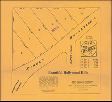
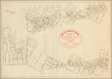
No Africans, No Mongolians and No Boring For Oil
Annotated Tract Map for the neighborhood immediately northwest of Laurel Canyon and Sunset Blvd, which includes an additonal slip of paper outlining details relating to the lots for sale in the development, including financing terms and a detailed restrictive covenant.
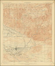
Laurel Heights, printed in the early 20th century, captures a pivotal moment in the urban development of Los Angeles. The area, delineated by notable roads such as Selma Avenue (then called Michigan Avenue, apparently), Laurel Canyon Road, Sunset Boulevard, and Fairfax Avenue (then Crescent Avenue), showcases the planned subdivision that lies between these iconic thoroughfares. The map, supplemented by hand corrections, displays the sales endeavors of C.A. Sumner & Co. and Roy E. Naftzger, both pivotal actors in Los Angeles real estate. Notes regarding lot prices, lots sold and the names of several buyers are given.
Advertisements for Laurel Heights began appearing in the Los Angeles Times and other newspapers as early as August 7, 1908. and the first appearance of an advertisement of Laurel Heights lots for sale by C.A. Sumner appeared on August 18, 1912.
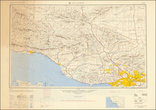
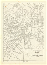
In the context of Los Angeles's growth, this map represents a chapter in the sprawling urbanization of a city on the verge of becoming a major hub for the entertainment industry. By the early 20th century, Hollywood was gradually transforming into the epicenter of American cinema. Consequently, areas such as Laurel Heights were emerging as sought-after residential districts, catering to the influx of professionals seeking proximity to the burgeoning movie studios.
However, the map reveals more than just urban planning and geographical contours; it bears testimony to prevailing societal norms and restrictions of the time. The attached terms and conditions portray a vivid picture of urban development standards. While guidelines like housing costs, infrastructure provisions, and architectural restrictions were typical, the racially restrictive covenant barring persons of "African or Mongolian descent" from owning or renting property echoes the darker underbelly of early 20th-century American socio-cultural landscapes.
Another covenant listed is a fascinating reflection of the prevalence of the oil boom in Southern California. The prohibition against "Oil Boring"
Furthermore, the inset map of the neighborhood contextualizes Laurel Heights within the greater expanse of Los Angeles, emphasizing its strategic location. The hand-scribbled prices on individual lots indicate a market in flux, while the attached slip of paper, detailing infrastructure provisions and purchasing terms, affords potential buyers a comprehensive understanding of what the neighborhood has to offer.
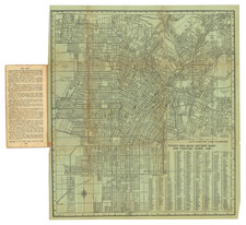
The partial text and panoramic photograph on the verso suggest that the map was likely part of a larger promotional pamphlet. Although the map itself is intact, the incomplete nature of the verso hints that some additional folding sections might be missing.
In conclusion, Laurel Heights stands not only as a testament to the methodical urban planning of early Los Angeles but also as a mirror reflecting the societal mores and prejudices of its time. It is a layered document that weaves together geography, commerce, and socio-cultural paradigms.
Date very roughly estimated.