


|
||

|

|
|

|
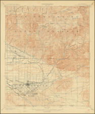
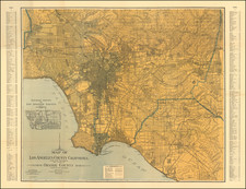
Fine original antique map of the easternmost San Berardino Valley, showing the early 20th-century layout of Redlands, Crafton, and Harlem Springs.
The map shows the valley in extremely fine detail, having been published by the USGS. Many place names, contour lines, streets, railways, and more are all named. Buildings are shown throughout. The map extends northto the San Berardino Mountains, just shy of Big Bear and Lake Arrowhead. The map extends just into Riverside County in the south.
Redlands saw growth at the start of the 20th century following the arrival of the railroads in the 1880s. Additional railroads arrived soon after the Southern Pacific, with a Street Railway Company even being founded. An interurban connection between Los Angeles and the area arrived in 1914, postdating the map. Redlands was famous for its citrus production at the time.
This map was originally surveyed in 1898 and 1899. This edition was first issued in August 1901, and this issue was printed in February 1909.
![San Bernardino County [and:] Southwest Portion of San Bernardino County](https://storage.googleapis.com/raremaps/img/small/96727.jpg)