|
||

|

|
|

|
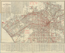
Stock# 81906
Description
Scarce 1920 folding street map of Los Angeles, published for a visitor guide and directory by F. W. Wood.
The map focuses on downtown Los Angeles, extending to Wilshire and Hollywood in the northwest. The Boyle Heights district is named at the right.
The map features an extensive list of streets not named on the map itself, which continues on the back of the map.
Condition Description
Folding map printed on front and back. The map mounted in the back of "Wood's Red Book Revised Maps 1920 Visitors Guide and Director yo Los Angeles and Vicinity" published for Holmes Book Co.