|
||

|

|
|

|
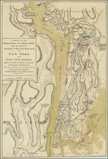
Amsterdam in New Netherland: The City of the Dutch West India Company by Townsend Mac Coun, copyrighted in 1909 and published in New York, offers a detailed depiction of the Dutch settlement in lower Manhattan, primarily focusing on the dense region south of Wall Street. This intricate map, concentrating on the period between 1653 and 1664, annotates the residences of the more notable citizens of the era and highlights significant locations in red, providing an invaluable window into the foundational years of what would become one of the world's most iconic urban landscapes.
During the mid-17th century, the Dutch established a formidable presence on the island of Manhattan, then part of the larger territory of New Netherland. Under the auspices of the Dutch West India Company, this settlement, known as New Amsterdam, became the administrative and commercial heart of their North American colonies. As the precursor to modern-day New York City, New Amsterdam's streets and structures, so meticulously mapped by Townsend Mac Coun, lay the groundwork for the future metropolis.
The specificity of the map, with its accentuation of individual names, reveals the nuanced social and economic fabric of this Dutch enclave. Notable figures such as Peter Stuyvesant, the last Dutch director-general of the colony, find mention alongside locations like the Stadt Huys (City Hall) and Fort Amsterdam, the primary military and administrative center of the colony. These annotations underscore the interconnectedness of commerce, governance, and daily life within this compact urban space.
Additionally, streets like the De Heere Straat, Marckvelt Straat, and Wall Street (originally a defensive wall on the northern boundary of the settlement) further elucidate the organized urban planning that characterized Dutch colonial endeavors. This structural organization, alongside the presence of infrastructural elements like the Town's Public Mill and various wharfs, hints at the nascent economic vibrancy that would define New York in centuries to come.
In conclusion, Amsterdam in New Netherland is more than just a map; it is an invaluable historical document that charts the early topographical and sociocultural evolution of Manhattan under Dutch rule. Through its careful detailing and annotations, it offers scholars, historians, and enthusiasts a glimpse into the foundational layers upon which the bustling metropolis of New York City was built.

![[Brooklyn] A Map of ten Lots of land bounded on high water mark as the same was deemed to be on the 20th day of May 1761 on the East River now Brooklyn Ferry in Kings County._ Resurveyed according to the original Map thereof on the first day of May 1813. . .](https://storage.googleapis.com/raremaps/img/small/47354.jpg)