


|
||

|

|
|

|
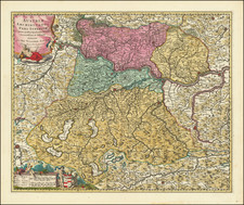
Bohemia & Moravia Provinces of Austria, published by William Lizars in Edinburgh circa 1830, offers an attractive portrayal of these pivotal central European territories. Focusing on the geographical heart at Prague, the capital city and historical center of the Bohemian region, the map is demarcated by regions, each distinctly colored to aid in their differentiation. With remarkable precision, it lays out the myriad towns, meandering roads, and prominent mountain ranges, reflecting the topographical intricacies of the region.
Bohemia and Moravia, historically significant provinces of the Habsburg-controlled Austrian Empire, have consistently maintained a prominent position in European geopolitics. By the early 19th century, they were at the crossroads of cultural, political, and economic developments in Central Europe. Their strategic importance, underscored by their rich cultural and historical tapestry, marked these provinces as significant nexuses of power, influence, and commerce.
This map, originating from the hands of the esteemed William Lizars, stands as a testament to the meticulous nature of 19th-century cartographic practices. Through its comprehensive details, it offers more than just topographical knowledge; it is an invitation to delve into the socio-political intricacies of the time. The coloring by regions, for instance, provides a subtle hint at the administrative divisions and complexities that underpinned the provinces' governance.
The prominence of Prague, represented not just as a geographical focal point but also as a historical and cultural beacon, underscores its centrality to the Bohemian narrative. The city, renowned for its architectural splendors and as a hub of intellectual pursuits, encapsulates the essence of the provinces' significance in this map.
The detailed representation of towns, from the most prominent to the lesser-known, alongside the intricate roadways, depicts a region teeming with activity. The natural features, notably the mountain ranges, stand as enduring markers of history, while also highlighting the natural boundaries that frequently influenced political and military strategies in this region.
The Lizars were a Scottish family of engravers and printers who produced many views and maps. Daniel Lizars Sr. (1754-1812) was the son of a shoemaker, but he apprenticed with Andrew Bell, a printer and engraver. Lizars set up his own printworks near St. Giles Cathedral and took on his own apprentices, including George Bartholomew, whose son John would go on to found the important mapmaking firm later know as John Bartholomew & Son Ltd.
Daniel Sr. had three sons: Daniel Jr., John, and William Home. He also had a daughter, Jane Home. Daniel Jr. (1793-1875), the youngest of the boys, apprenticed in his father’s shop alongside George Bartholomew. When his father died in 1812, Daniel Jr. took over much of the business, expanding it and specializing in maps. The company went bankrupt in 1832, however, and Daniel emigrated to Canada.
John Lizars (1792-1860), the middle son, studied medicine and became Professor of Surgery at the Royal College of Surgeons of Edinburgh, as well as senior surgeon at the Royal Infirmary of Edinburgh.
William Home Lizars (1788-1859), the eldest, also apprenticed in his father’s shop. After learning engraving, William entered the Trustees’ Academy to learn under John Graham. He was a skilled painter and artist. When his father died, and after his Daniel Jr. left, he carried on printing and invented a method of etching that looks like wood engraving.
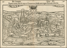
![[Praga urbs amplissima regni Bohemiae metropolis sedes augusti Romanorum imperatoris.]](https://storage.googleapis.com/raremaps/img/small/80625.jpg)
![(Italy and Austria) Carta geografica statistica postale dell’I.R. Monarchia Austriaca e dell’Italia [Statistical postal geographic map of the Imperial Royal Austrian Monarchy and of Italy]](https://storage.googleapis.com/raremaps/img/small/94038.jpg)
![[Holy Roman Empire] A Newe Mape of Germany Newly Augmented by Iohn Speed Ano Dom: 1626](https://storage.googleapis.com/raremaps/img/small/67323.jpg)