|
||

|

|
|

|
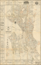
Parker's Map: Official Map of Tacoma Real Estate Association, City of Tacoma, a color lithographed city plan published in 1917 under the copyright of J. C. Parker, is a comprehensive depiction of Tacoma, highlighting its civic institutions and neighboring military presence.
Schools are demarcated by red boxes, while hospitals are identified with boxes bearing an "X". An inset in the lower left accentuates the broader vicinity of Tacoma, notably spotlighting the expansive U.S. Army Post located to its south.
At the dawn of the 20th century, Tacoma was witnessing an era of growth and urban refinement. It was evolving not only as a hub of commerce in the Pacific Northwest but also as a community valuing education and healthcare. The inclusion of specific symbols to represent schools and hospitals on the map underscores these societal priorities, reflecting a city attentive to the well-being and enlightenment of its citizens.
The lithographic technique employed in the map, utilizing a harmonious palette of blue, yellow, red, black, and green, showcases the printmaking advancements of the era. The artistry and precision in blending these colors provide the map with both aesthetic appeal and clarity in detail. This clarity, combined with the map's deliberate choice of symbols and insets, transforms it from a mere navigational tool into a historical document, capturing the essence of Tacoma in 1917.