|
||

|

|
|

|
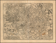
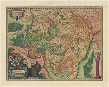
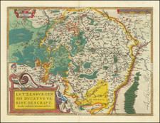
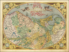
Striking late 16th Century set of images showing the urban landscape of Luxembourg, a city renowned for its strategic military significance and aesthetic beauty, emphasized by its mountainous and uneven terrain. The views offered are a testament to the city's architectural grandeur and its harmonious integration with the rugged natural surroundings.
The commentary by Braun highlights the city’s notable religious establishments, such as the magnificent Franciscan monastery and the splendid monastery referred to as the minster. The geographical layout of Luxembourg is described in a manner that reflects its defensive considerations and urban evolution. The Old Town, nestled in the depths of a valley, gradually gave way to the more secure Upper Town, elevated upon a cliff, demonstrating the city's adaptation to its topographical challenges. The move to higher ground is noted as a strategic shift, made to enhance the city's defensibility.
Luxembourg Palace, depicted in the lower view, served as the opulent residence of Peter Ernst I of Mansfeld. His tenure as commander of the Spanish armies and governor of Luxembourg, among other titles, spanned a significant part of the late Renaissance period. The palace, with its elaborate gardens, exemplifies Renaissance tastes and architectural trends. The accompanying text draws attention to the palace's remarkable interior, adorned with exceptional paintings and antiquities, indicative of the cultural and artistic richness of the era.
The Igel Column, prominently illustrated to the right, stands as a monument to the ancient world's craftsmanship and the legacy of the Roman presence in the region. Erected by a family of cloth merchants, the Secundinii, the column’s reliefs narrate tales of commercial success and daily life in antiquity. This funerary monument, a rare relic north of the Alps and now recognized as a UNESCO World Heritage Site, captivates the observer with its intricate artistry and the historical narrative it encapsulates.
Together, these images not only showcase the grandiosity of Renaissance Luxembourg and its Roman heritage but also serve as a visual chronicle, preserving the essence of a cityscape that deftly melds the cultural sophistication of human settlement with the stark, imposing beauty of its natural environment. Braun & Hogenberg’s work, through detailed cartographic artistry, allows us to traverse time, offering a window into the soul of a historic European capital and its enduring monuments.
Civitates Orbis Terrarum: The Greatest City Book
Georg Braun and Frans Hogenberg began the process of creating a comprehensive atlas of the cities of the world in 1572. Their book, Civitates Orbis Terrarum, was originally intended as a companion to Abraham Ortelius's Theatrum Orbis Terrarum, the first true atlas.
The great atlas was edited by Georg Braun, with Franz Hogenberg engraving many of the views. When the project was finished, the series would contain over 546 views (sometimes with multiple views on a single plate).
Civitates Orbis Terrarum includes the work of over 100 artists and topographers, perhaps most notable among them was the superlative talent of Joris Hoefnagel (1542-1600). He provided original drawings of Spanish and Italian towns, as well as reworking and improving the town drawings of other artists. After Joris's death, his son Jakob continued the project.
The Civitates provides an incredibly comprehensive view of urban life in the late 16th century. Many of the views in these volumes are the earliest of their respective towns -- either absolutely, or they are predated only by impossible rarities, as in the case of London. Cities portrayed range from the great capitals of Europe, Asia, Africa, and the Americas to small Swiss hamlets and other tiny villages. As such, this singular and indispensable source for understanding the early modern world.
The work was published in six volumes, each of which contained approximately sixty plates. The subject matter of each plate varied widely, it could provide a single view of a city, two views of the same city, or views of up to nine different cities. The range of designs is extensive, and it is interesting to compare the variety between views of the same city by two different authors.
Georg Braun (1541-1622) was born and died in Cologne. His primary vocation was as Catholic cleric; he spent thirty-seven years as canon and dean at the church St. Maria ad Gradus, in Cologne. Braun was the chief editor of the Civitates orbis terrarum, the greatest book of town views ever published. His job entailed hiring artists, acquiring source material for the maps and views, and writing the text. In this role, he was assisted by Abraham Ortelius. Braun lived into his 80s, and he was the only member of the original team to witness the publication of the sixth volume in 1617.
Frans Hogenberg (ca. 1540-ca. 1590) was a Flemish and German engraver and mapmaker who also painted. He was born in Mechelen, south of Antwerp, the son of wood engraver and etcher Nicolas Hogenberg. Together with his father, brother (Remigius), uncle, and cousins, Frans was one member of a prominent artistic family in the Netherlands.
During the 1550s, Frans worked in Antwerp with the famous mapmaker Abraham Ortelius. There, he engraved the maps for Ortelius’ groundbreaking first atlas, published in Antwerp in 1570, along with Johannes van Deotecum and Ambrosius and Ferdinand Arsenius. It is suspected he engraved the title page as well. Later, Ortelius supported Hogenberg with information for a different project, the Civitates orbis terrarium (edited by Georg Braun, engraved by Hogenberg, published in six volumes, Cologne, 1572-1617). Hogenberg engraved the majority of the work’s 546 prospects and views.
It is possible that Frans spent some time in England while fleeing from religious persecution, but he was living and working in Cologne by 1580. That is the city where he died around 1590. In addition to his maps, he is known for his historical allegories and portraits. His brother, Remigius, also went on to some fame as an engraver, and he died around the same time as his brother.
![[Napoleon's Battles in France, Belgium Netherlands, Luxembourg, Germany] No. 1 Frontiere du Nord. Mesny 5.](https://storage.googleapis.com/raremaps/img/small/60727.jpg)