|
||

|

|
|

|
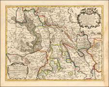
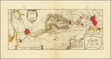
A finely detailed map of the Cathlolic Low Countries, published in Amsterdam, circa 1700.
The map illustrates the main provinces of the Catholic Low Countries, including Brabant, Limburg, Luxembourg, Gueldre, Flandres, Artois, Hainaut, Namur, Anvers, Malines, etc. A beautifully engraved title cartouche and scale of miles are featured. Also shown are abbeys, archdioces, bishop's palaces, universities, etc. The map also shows topographical features such as forests, lakes, and mountains.
Two separate sheets accompany the map. The first is an alphabetical table of place names within the Catholic Low Countries. The second sheet includes detailed town plans of Mons, Limburg, Cambray, Conde, and Phillipeville.
Pierre, or Pieter, Mortier (1661-1711) was a Dutch engraver, son of a French refugee. He was born in Leiden. In 1690 he was granted a privilege to publish French maps in Dutch lands. In 1693 he released the first and accompanying volume of the Neptune Francois. The third followed in 1700. His son, Cornelis (1699-1783), would partner with Johannes Covens I, creating one of the most important map publishing companies of the eighteenth century.
![[ Rotterdam ] Roterodamum, Hollandiae in ostio Roteri Flu Opp. Magni il:lius Desiderij Erasmi Patria](https://storage.googleapis.com/raremaps/img/small/96869.jpg)