


|
||

|

|
|

|
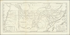
Rare map of Florida and the Southeastern part of the United States, first published in 1678 by Johann Christoph Beer in his Geographiae Universalis.
Beer's map is derived from Pierre Du Val's rare map of Florida, first published in 1660, although as noted by Burden, the engraver, Sigismund Hipschmannh, has in fact copied the third state of the Duval, which was first published in 1672.
The map provides an interesting projection of the shape of Florida, which derives from Sanson's maps. St. Augustine is named in Florida, as is Tegeste, the Cape of Florida, the B(ay) of S(aint) Joseph and S(an) Mateo. "Floride Francois (French Florida) is also noted to the north of Caroline ou Charlesford, along with the word Apache and two mythical lakes in the interior of the Southeast.
The Mississippi River (Rio del Spiritu S) is shown more prominently than the other rivers converging on the Mississippi Delta, prior to the improvements at the end of beginning of the 18th Century brought about by the manuscript maps of Nicholas De L'Isle.
Interestingly, this is also one of the earliest maps of the region to use the name Florida, rather than the French name "Floride."
States of the map
There are two states of the map:
- State 1: #66 in top right corner.
- State 2: #85 in the top left corner.
Rarity
The map is very rare on the market. This is the second example of the map we have seen on the market.

![[Hand Drawn Map] Le Golfe de Mexique avec les Pays Circonvoisins](https://storage.googleapis.com/raremaps/img/small/91580.jpg)