|
||

|

|
|

|
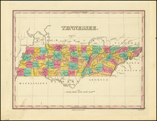
The First Map of the State of Tennessee
An excellent example of the second state of Mathew Carey's map of Tennessee, published in Carey's American Atlas.
Carey's American Atlas was the first atlas published in the United States, compiling a number of excellent maps from indigenous sources in the first compilation of American maps. This is the second state of the map, issued in 1796 and distinguishable from the earlier edition by the word state in the title, rather than Tennassee Government.
An excellent topographical map, showing settlements, trails, roads, Indian boundaries and Indian Towns. Reference table also indicates that the width of rivers in yards are shown.
The map was first advertised in conjunction with Carey's publication of Daniel Smith's A Short Description of the Tennassee Government… in 1793 but was not issued in that work and was first available as an insert to the work in January 1794.
The map includes wonderful annotations concerning the soil, grass, timber and other details of Western Tennessee, the south boundary of a military reservation, the Kentucky Road etc. The boundaries of 8 early counties are also noted.
An essential map for Tennessee collectors.

![[ Cherokee Nation ] A Map of the Tennassee Government formerly Part of North Carolina from the latest Surveys. 1795.](https://storage.googleapis.com/raremaps/img/small/100899.jpg)