


|
||

|

|
|

|
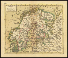
Scandinavia Including Sweden, Norway & Denmark, published by William Lizars in Edinburgh in 1830, presents a comprehensive cartographic depiction of the Nordic region, encompassing the kingdoms of Sweden, Norway, and Denmark. The map is notably enhanced by an inset of Iceland, situated in the upper left corner, offering a broader scope of the northern European landscape during the early 19th century.
The 1830s bore witness to significant geopolitical changes in Scandinavia. With Norway's recent separation from Denmark in 1814, followed by a brief union with Sweden, the region was in a period of diplomatic and territorial realignment. This map, thus, not only delineates the geographical boundaries but also provides insight into the political landscape of the time. The inclusion of Denmark, despite its southern position, emphasizes its historical and cultural ties to the Scandinavian peninsula.
Lizars' detailed representation showcases the intricate fjords of Norway, the sprawling Swedish lakes, and the Danish archipelago, capturing the diverse topographies and natural beauty of the region. The choice to incorporate Iceland as an inset suggests the island's growing relevance, possibly due to increasing exploration and trade endeavors or as an acknowledgment of its cultural and historical affiliations with Scandinavia.
The map's publication by William Lizars, a distinguished name in the cartographic circles of Edinburgh, signifies the high standards of engraving and geographical precision of the era. By focusing on Scandinavia, it sheds light on a region that was, at the time, experiencing both political shifts and a growing interest from the broader European community, thereby encapsulating a pivotal moment in the history of northern Europe.
The Lizars were a Scottish family of engravers and printers who produced many views and maps. Daniel Lizars Sr. (1754-1812) was the son of a shoemaker, but he apprenticed with Andrew Bell, a printer and engraver. Lizars set up his own printworks near St. Giles Cathedral and took on his own apprentices, including George Bartholomew, whose son John would go on to found the important mapmaking firm later know as John Bartholomew & Son Ltd.
Daniel Sr. had three sons: Daniel Jr., John, and William Home. He also had a daughter, Jane Home. Daniel Jr. (1793-1875), the youngest of the boys, apprenticed in his father’s shop alongside George Bartholomew. When his father died in 1812, Daniel Jr. took over much of the business, expanding it and specializing in maps. The company went bankrupt in 1832, however, and Daniel emigrated to Canada.
John Lizars (1792-1860), the middle son, studied medicine and became Professor of Surgery at the Royal College of Surgeons of Edinburgh, as well as senior surgeon at the Royal Infirmary of Edinburgh.
William Home Lizars (1788-1859), the eldest, also apprenticed in his father’s shop. After learning engraving, William entered the Trustees’ Academy to learn under John Graham. He was a skilled painter and artist. When his father died, and after his Daniel Jr. left, he carried on printing and invented a method of etching that looks like wood engraving.
![[Spitzbergen & Wiches Lande]](https://storage.googleapis.com/raremaps/img/small/61990.jpg)
![[ Scandinavia ] Tabula Geographica Regnorum Sueciae Daniae et Norwegiae](https://storage.googleapis.com/raremaps/img/small/102797.jpg)