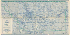
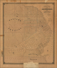
|
||

|

|
|

|
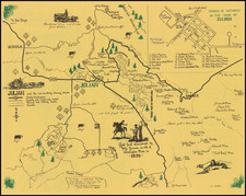
Preparing For The Damming of Sweetwater River and Creation of the Sweetwater Dam
Finely executed manuscript survey map of a portion of the Jamacha Rancho, illustrating the Jamul Road, Sweetwater River, proposed Dam Site for the Sweetwater Dam and farm buildings down River identified As "Little's".
A note at the bottom states that this map was used as an Exhibit to the complaint filed in the Superiod Court of San Diego County, in The Sweetwater Valley Irrigation Company v. Mary Eddy, with a docketing date of Sept 12, 1886, and is endorsed by the Clerk of the Superior Court on that date on the verso.
At the southwest corner of the map, the name "Little's" appears. This would be the Littles Farm. During the 1880s, the Jamacha Valley was an agricultural haven with fields of wheat, oats, barley, and corn in lowlands and groves of fruit trees on the hillsides. David Little, a Scottish immigrant had a fruit orchard and raised chickens and 69 bees.
The map references Lot F, one of the lots created in 1881 at the time of final confirmation of the partition of the original Rancho Jamacha to its then-current owners.
The history of the Jamacha Rancho's dates back to the early 19th century, illuminates a crucial facet of San Diego's socio-economic evolution. Known as "Rancho Jamacha," the 8,881-acre Mexican land grant in present-day San Diego County was conferred by Governor Juan Alvarado in 1840 to Apolinaria Lorenzana, a single woman who came to the San Diego Mission at age 12 and became a beloved figure in the last days of the Mission, before it was abandoned in the 1840s. The Rancho stretched eastward from Rancho de la Nación, encompassing parts of La Presa, Spring Valley, Lemon Grove, Encanto, and Jamacha, with the Sweetwater River providing its vital water source. The name "Jamacha," derived from indigenous roots, became synonymous with the land.
The land in question would become part of the Monte Vista Ranch. At the time of the partition of the land in March 1881, the land was owned by Mary H. Eddy (widow of San Diego Pioneer Asher Eddy, see below), to whom the court conferred the original "Plat F", consisting of approximately 3102 acres. The court, after investigating the legitimacy of the various claims, ordered that the rancho be surveyed and subdivided into nine parcels designated Plats A through I were surveyed. Plats A through F were in the Jamacha Valley, with Plat G being at the southwestern most part of the Rancho. Over the course of the next decade, the land changes hands several times.
Sweetwater Dam & Reservoir
The dam shown on the map is today's Sweetwater Dam, a significant development in the area's water infrastructure. The need for a steady and reliable water source in the arid climate of Southern California led to its construction. First suggested by Frank Kimball in 1869, it was not until the land was acquired by the San Diego Land & Town Company that the project came to fruition. Work on the dam began in November 1886 and was completed by March 1888, under the supervision of James D. Schuyler, a prominent civil engineer of the era.
The dam and the lands used for the reservoir site cost approximately $234,000, which was a substantial investment in the late 19th century. The entire system of distribution exceeded half a million dollars. Once completed, the reservoir had a capacity of 7 billion gallons, which provided a crucial water supply for several communities in the area, including National City, Chula Vista, and parts of Sweetwater Valley.
The Otay Water Company, founded in March 1886 with E. S. Babcock as the principal owner, was initially focused on irrigating the Otay Valley lands and the adjacent mesa. In 1895, Babcock sold a half-interest to the Spreckels brothers, who were prominent figures in the local business community, and the company was renamed the Southern California Mountain Water Company.
The Spreckels brothers eventually became the sole owners of the company, furthering its expansion and influence in the region. The company undertook a major project in the early 20th century to supply the entire water supply to the city of San Diego. It built a storage dam at Moreno and extended its pipeline to the city's reservoir, which began delivering water in the summer of 1906.
This series of developments, including the construction and operation of the Sweetwater Dam, were pivotal moments in San Diego's history, shaping the growth and development of the region. They illustrate the significant role of water management in the American West, an area often prone to droughts and water shortages. The Sweetwater Dam, along with the other water infrastructure developed during this era, paved the way for the sustained growth and expansion of these southern California communities.
Asher R. Eddy
Asher R. Eddy, began his military career as cadet at the US Military Academy in 1840. Over nearly four decades, he served in various capacities, from being stationed at forts across the U.S. to being an Assistant Professor of Mathematics at the Academy. During the Civil War, Eddy played pivotal roles in managing supply depots and served as Chief Quartermaster in several regions.
Eddy's presence in San Diego began as early as 1850, shortly after California's admission to the Union. His assignment on frontier duty in San Diego in 1850-51 coincided with the infancy of the American military establishment in the region.
While stationed in San Diego, Eddy would have had firsthand interactions with the local inhabitants, and it was here he developed his relationships that would later result in business ventures such as his partnership in Rancho Jamacha. His experience in San Diego provided him with insights into the strategic value of the region, both militarily and economically. His service in California included a posting at the New Town Commissary Depot from 1851-54.
Beyond his military service, Eddy was also a prominent businessman and private landowner in San Diego County. He owned a cottage and lots in New San Diego and, with Colonel Magruder and others, controlled Rancho Jamacha, which was previously managed by Dona Apolinaria Lorenzana under Juan Forster. Magruder secured grazing rights for Army livestock there in 1852, leading to a partnership involving Eddy, Magruder, and 3 other partners. Although Lorenzana sought her property's return from the U.S. Land Commission, a deal in 1853 saw Magruder sell two-thirds of the ranch to the partnership, pending Lorenzana's claim confirmation. The partners aimed to develop Jamacha Ranch into a breeding farm, but by the 1860s, ranching became unprofitable in the region. A flood in 1861 and subsequent droughts diminished their livestock until 1868.
In 1912, Sefton Investment Company acquired most of Plat F.