|
||

|

|
|

|
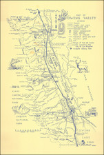
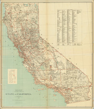
Map of Kern County Cal., drawn and published by Punnett Brothers in 1908, provides a detailed depiction of Kern County, California at the dawn of the 20th century. Housed within the MacDonough Building on Kearny Street, San Francisco, the Punnett Brothers were well-regarded for their regional California cartography, and this map stands as a testament to their skills.
The late 19th and early 20th centuries were transformative times for California. The discovery of oil in Kern County in 1899, coupled with the ongoing Gold Rush, saw the state rapidly developing in both infrastructure and population. This map captures a snapshot of Kern County in the midst of these changes, offering insights into the evolving landscape and settlement patterns that would set the stage for California's rise to prominence in the subsequent decades.
The medium, a blueline print, was a prevalent reproduction technique during this period. Known for its sharp contrasts and clarity, this method ensured that the intricate details and nuances of the original drawing were maintained. The Punnett Brothers, by employing this method, ensured that their map remained both functional for its intended audience and aesthetically pleasing for future generations of enthusiasts and scholars.