|
||

|

|
|

|
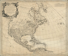
Rare First Edition of the "Treaty Map" Owned by a Major Mexican General and Politician.
General de División Lino José Alcorta's copy of the 1828 White, Gallaher & White map of Mexico, Texas, and the American Southwest.
The map is essentially a copy of Tanner's 1826 Map of Mexico, but with Spanish text. The present map is the only edition from its run published by White, Gallaher & White, with all following maps being published by John Disturnell.
The importance derives from the attachment of two later Disturnell editions to the two official copies of the Treaty of Guadalupe Hidalgo, which settled the Mexican-American War. The importance of the Treaty to the settling of the border between the United States and Mexico means that the so-called Treaty Sequence maps (of which this is the first) are of fundamental importance to the mapping of the United States and Mexico.
As it was published in 1828 (and based on a map from 1826), the White, Gallaher & White predates the acquisition by Tanner of Stephen F. Austin's manuscript maps of Texas. Therefore, this represents one of the best renditions of Texas to predate the monumental changes that the region would experience in the 1830s.
The California coast is plagued by the cartographic errors that characterized much mapping of that part of the West during the first decades of the 19th century.
Lawrence Martin's “John Disturnell’s Map of the United Mexican States” in Ristow’s A la Carte, pages 207-209 (discussion) discusses the context of the White, Gallaher & White with respect to the Disturnell editions and the Treaty of Guadalupe Hidalgo:
In 1828 a plagiarism of Tanner’s of Mexico was published under a Spanish title by White, Gallaher & White, of New York. Eventually some 24 different editions of this map were published at New York, all but the first by Disturnell, and the map has become widely known as Disturnell’s map. That the White, Gallaher & White map was plagiarized from Tanner’s is suggested not merely by the similarity in titles. The two maps share common errors, for courses of the rivers, and they have the same insets: a large-scale map of the area between Vera Cruz and Mexico, a highly individual table of statistics, and a long table of distances. The latter map used all of Tanner’s explanatory remarks, which were translated word for word....
It is curious that, although White, Gallaher & White’s map was an obvious plagiarism of Tanner’s copyrighted map and both were published in the United States the later map was also copyrighted. Outside its lower neat line, near the right border, appear the words ‘Entered according to Act of Congress, May 31st, 1828, by White, Gallaher & White.’ This suggests that Tanner’s map may have been used by friendly agreement to compile the slightly enlarged Spanish language map, but it seems odd that White, Gallaher & White made no public acknowledgment to Tanner.
The earliest identified edition of Disturnell’s reprint was published in 1846, doubtless because of the outbreak of the Mexican War. Its title information is identical with the White, Gallaher & White map except for date and publisher. The two maps were printed from the same plates, as is indicated by the faint copyright notice, which was incompletely eradicated and shows on the borders of all but two of Disturnell’s editions printed between 1846 and 1858.
As noted by Martin, following the publication of the 1828 White Gallaher & White map, the plates apparently languished in New York until the beginning of the war with Mexico, when they were apparently printed as Disturnell's map, which was issued from 1846 until the early 1860s (in 2010, we handled an edition dated 1862, the latest example we have encountered).
White, Gallaher & White were popular publishers based in New York and working during the 1820s and '30s. They produced, for example, some of Emma Willard's books.
Provenance: General de División Lino José Alcorta (1794-1854)
Underneath the title, the map bears a neat manuscript inscription: "Propiedad del Señor General de Brigada D. Lino Jose Alcorta"
Paul G. Pierpaoli Jr., writing in The Encyclopedia of the Mexican-American War (2013), provides the best biography of Alcorta that we have found:
Mexican brigadier general during the Mexican-American War. Lino José Alcorta was born in Veracruz, Mexico, in 1794. In July 1813 he entered military service as a cadet in the Cazadores de América Regiment. As a royalist during the Mexican wars for independence he participated in numerous clashes with independence forces, earning the reputation as an intrepid soldier. In 1821, however, Alcorta subscribed to the Plan of Iguala and swore his loyalty to Agustín de Iturbide. He rose steadily through the ranks and distinguished himself during the 1829 Spanish invasion of Tampico, during which he helped repel Spanish forces and ended Spain's attempt to retake its former colony. Thereafter Alcorta held a series of increasingly important military posts.
By 1840, Alcorta had been promoted to brigadier general. That same year, he was instrumental in quashing a rebellion in Mexico City against President Anastasio Bustamante's centralist government fomented by Brigadier General José Urrea. During the 12-day struggle, Alcorta sustained a serious head wound, but he refused to relinquish his command. In 1844, he became military commander at San Luis Potosí, and when the Mexican-American War began two years later Alcorta was chief of the general staff. He oversaw the early struggles against Major General Zachary Taylor's forces in northern Mexico and quickly became one of General Antonio López de Santa Anna's most trusted subordinates and confidantes. After the April 17-18, 1847, Battle of Cerro Gordo, Alcorta began serving as minister of war and marine, a post he held for the remainder of the conflict.
Realizing that Mexican forces could not overcome the Americans' far superior firepower and discipline, Alcorta came to favor multiple, simultaneous hit-and-run attacks against U.S. forces by Mexican contingents of no more than 2,000 men each. After the raids Mexican forces could quickly disappear into the countryside to avoid capture and detection. He strongly believed that large, pitched battles should be avoided. It was the Americans, however, and not the Mexicans, who largely determined the size and pacing of set-piece engagements. After the Battle of Chapultepec on September 13, 1847, and as U.S. troops were breaching the gates of Mexico City, Alcorta was among three of Santa Anna's senior commanders who recommended a quick capitulation of the capital city to avoid unnecessary civilian casualties.
After the end of the war, Alcorta remained in the army for a time but in 1851 became vice president of the Mexican Society of Geography and Statistics. He held that position until becoming minister of war-again-in Santa Anna's last government. Alcorta died in office in Mexico City in 1854.
![[ Climatology ] Map of California Illustrating Its Climatology -- Comparative Area -- Rail Lines -- Compiled From Official and Authentic Sources By The Southern Pacific . . . 1903](https://storage.googleapis.com/raremaps/img/small/82610.jpg)
![(Aztec Tribute List) [Original watercolor showing tribute items paid to the Aztecs by subject towns] Mendoza Col. part 1s Lorenzana, Aglio 1, Vol 22...](https://storage.googleapis.com/raremaps/img/small/102321.jpg)
![[Dallas / Kennedy Assassination] La Mappa Dell'Odio](https://storage.googleapis.com/raremaps/img/small/89006.jpg)