|
||

|

|
|

|
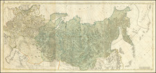
Detailed map of Russia by Herman Moll, one of the leading English mapsellers of the early 18th Century.
The map provides an outline of European Russia during the first half of the 18th century. It displays major cities, rivers, and mountains, defining a region that stretches from Eastern Europe to Siberia.
The map also highlights Russia's acquisitions from Sweden, a result of the Great Northern War. The war began as a coordinated effort by Russia, Denmark-Norway, and Saxony-Poland-Lithuania to break Swedish control over parts of Northern and Eastern Europe. The coalition aimed to take advantage of what they perceived as a weak and inexperienced Swedish king, Charles XII. Charles XII initially defeated Denmark and Saxony-Poland-Lithuania, turning his focus toward Russia. However, the tide turned at the Battle of Poltava in 1709, where the Russian forces under Peter the Great decisively defeated the Swedish army.
Following Poltava, the war dragged on with various campaigns and alliances, but the momentum had shifted in Russia's favor. The Treaty of Nystad was signed in 1721, ending the Great Northern War and marking the rise of Russia as a dominant power in Northern Europe. Under the treaty's terms, Russia acquired significant territories from Sweden, including parts of modern-day Estonia, Latvia, and Finland, such as Livonia, Ingria, and Karelia. These acquisitions not only expanded Russia's territory but also gave it vital access to the Baltic Sea, paving the way for the construction of St. Petersburg and enhancing Russia's influence in European affairs.
The acquisition of these territories signified a decline in Swedish power and a shift in the balance of power in the region, further underlining Russia's emergence as a key player on the European stage. The map by Herman Moll would have captured this geopolitical change, presenting the Russian Empire's new boundaries and reflecting the new political landscape of Northern Europe.
Two notes emphasize the sheer size of Russia, comparing it to eight times the size of France and equal to the Turkish Empire. A brief annotation acknowledges the recent construction of St. Petersburg, an ambitious project initiated by Peter the Great to connect Russia with Western Europe.
Herman Moll (c. 1654-1732) was one of the most important London mapmakers in the first half of the eighteenth century. Moll was probably born in Bremen, Germany, around 1654. He moved to London to escape the Scanian Wars. His earliest work was as an engraver for Moses Pitt on the production of the English Atlas, a failed work which landed Pitt in debtor's prison. Moll also engraved for Sir Jonas Moore, Grenville Collins, John Adair, and the Seller & Price firm. He published his first original maps in the early 1680s and had set up his own shop by the 1690s.
Moll's work quickly helped him become a member of a group which congregated at Jonathan's Coffee House at Number 20 Exchange Alley, Cornhill, where speculators met to trade stock. Moll's circle included the scientist Robert Hooke, the archaeologist William Stuckley, the authors Jonathan Swift and Daniel Defoe, and the intellectually-gifted pirates William Dampier, Woodes Rogers and William Hacke. From these contacts, Moll gained a great deal of privileged information that was included in his maps.
Over the course of his career, he published dozens of geographies, atlases, and histories, not to mention numerous sheet maps. His most famous works are Atlas Geographus, a monthly magazine that ran from 1708 to 1717, and The World Described (1715-54). He also frequently made maps for books, including those of Dampier’s publications and Swift’s Gulliver’s Travels. Moll died in 1732. It is likely that his plates passed to another contemporary, Thomas Bowles, after this death.
![[ Scandinavia ] Tabula Geographica Regnorum Sueciae Daniae et Norwegiae](https://storage.googleapis.com/raremaps/img/small/102797.jpg)
![[Nova Zembla]](https://storage.googleapis.com/raremaps/img/small/75007.jpg)