


|
||

|

|
|

|
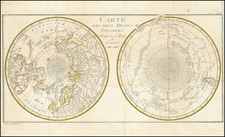
Rare early depiction of Novaya Zemlya, illustrating details from Willem Barentsz's second expedition.
The map shows New Zemlya and Russia separated by Waygats/Nassau strait, with the Nort See to one side, Mare Glaciale to other.
The map would seem to detail the results of the second voyage. In 1595, Prince Maurice of Orange, upon hearing of Barentsz' previous voyage, named him chief pilot and conductor of a new expedition, which was accompanied by six ships loaded with merchant wares that the Dutch hoped to trade with China. The voyage went between the Siberian coast and Vaygach Island, as shown on the map. on August 30, the party came across approximately 20 Samoyed "wild men" with whom they were able to speak, due to a crewmember speaking their language, again shown. On September 4, small crew sent to States Island to search for a type of crystal was attacked by a polar bear, and two sailors were killed (far right toward the bottom).
Eventually, the expedition turned back upon discovering that unexpected weather had left the Kara Sea frozen.This expedition was largely considered to be a failure

![[Soviet Russian Ecology Propaganda Poster] Основы Водного Законодательства Союза ССР](https://storage.googleapis.com/raremaps/img/small/68343.jpg)
![[ Poland / Lithuania / Kaliningrad ] Das Konigreich Preussenmit den freien Stadten Danzig u Thorn](https://storage.googleapis.com/raremaps/img/small/102639.jpg)
![[Soviet Union] Our Country -- From Wooden Plough To Sputnick](https://storage.googleapis.com/raremaps/img/small/47092.jpg)
